Pacific, MO
| Pacific, Missouri | |
|---|---|
| City | |
| City of Pacific | |

Downtown Pacific in August 2013
|
|
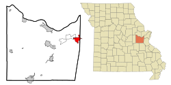
 Location of Pacific, Missouri |
|
| Coordinates: 38°28′53″N 90°45′0″W / 38.48139°N 90.75000°WCoordinates: 38°28′53″N 90°45′0″W / 38.48139°N 90.75000°W | |
| Country | United States of America |
| State | Missouri |
| Counties | Franklin, St. Louis |
| Government | |
| • Mayor | Jeff Palmore |
| Area | |
| • Total | 5.93 sq mi (15.36 km2) |
| • Land | 5.92 sq mi (15.33 km2) |
| • Water | 0.01 sq mi (0.03 km2) |
| Elevation | 466 ft (142 m) |
| Population (2010) | |
| • Total | 7,002 |
| • Estimate (2016) | 7,210 |
| • Density | 1,200/sq mi (460/km2) |
| Time zone | Central (CST) (UTC-6) |
| • Summer (DST) | CDT (UTC-5) |
| ZIP codes | 63055, 63069 |
| Area code(s) | 636 |
| FIPS code | 29-55910 |
| GNIS feature ID | 0731630 |
Pacific is a city in Franklin and St. Louis counties in the U.S. state of Missouri. The population was 7,002 at the 2010 census.
Pacific was platted in 1852 when the railroad was extended to that point. It was so named because here the new railroad started for the Pacific Ocean. A post office called Pacific has been in operation since 1854.
The Gustav Grauer Farm was listed on the National Register of Historic Places in 1984.
Pacific is located at 38°28′53″N 90°45′0″W / 38.48139°N 90.75000°W (38.481503, -90.750015). The city straddles the Franklin County/St. Louis County line, which lies halfway on the blocks between Elm and Neosho streets. St. Louis is 30 miles (50 km) northeast of Pacific, and the communities comprising the Missouri Rhineland are 20 miles (30 km) northwest of the city.
Pacific is bordered on the southeast by the Pacific Palisades Conservation Area. Access to the Meramec River, through the Pacific Palisades Conservation Area, is located east of the city next to Eureka on the north side. The majority of the Pacific Palisades Conservation Area is south of the river and can be accessed 1 mile (1.6 km) south of the city in Jefferson County.
...
Wikipedia
