Pljevlja
|
Pljevlja Пљевља / Pljevlja |
|||
|---|---|---|---|
| City | |||
| Municipality of Pljevlja | |||
|
|||
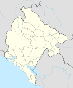
| Location of Pljevlja | |||
| Coordinates: 43°22′N 19°22′E / 43.36°N 19.36°E | |||
| Settlements | 153 | ||
| Government | |||
| • Mayor | Mirko Đačić (DPS) | ||
| Area | |||
| • Total | 1,346 km2 (520 sq mi) | ||
| Population (2011 census) | |||
| • Total | 19,489 | ||
| • Density | 27/km2 (70/sq mi) | ||
| • Municipality | 30,786 | ||
| Postal code | 84210 | ||
| Area code | +382 89 | ||
| ISO 3166-2 code | ME-14 | ||
| Car plates | PV | ||
| Website | http://www.pljevlja.me/ | ||
Pljevlja (Montenegrin Cyrillic: Пљевља, pronounced [pʎêʋʎa]) is a town and the center of Pljevlja Municipality located in the northern part of Montenegro. The city lies at an altitude of 770 m (2,530 ft). In the Middle Ages, Pljevlja had been a crossroad of the important commercial roads and cultural streams, with important roads connecting the littoral with the Balkan interior. In 2011, the municipality of Pljevlja had a population of 30,786, while the city itself had a population of about 19,489. The municipality borders those of Žabljak, Bijelo Polje and Mojkovac in Montenegro, as well as the republics of Serbia and Bosnia and Herzegovina. With a total area of 1,346 km2 (520 sq mi), it is the third largest municipality in Montenegro.
The city lies at an altitude of 770 m (2,530 ft). The municipality borders those of Žabljak, Bijelo Polje and Mojkovac in Montenegro, as well as the republics of Serbia and Bosnia and Herzegovina. With a total area of 1,346 km2 (520 sq mi), it is the third largest municipality in Montenegro.
First traces of human life in the region dates to 50,000 and 40,000 BC, while reliable findings show that the Ćehotina River valley was inhabited at latest around 30,000 BC. The oldest traces of human presence in the town area, a flint tool, had been found in the cave under Gospić Peak. The traces of settlements in the later stages of the Stone Age were found in two large archaeological sites called Mališina Stijena and Medena Stijena (around 10,000 stone tools and arms), dating to 12,000–8,000 BC. During the Bronze and Iron Age, since around 2,000 BC up until the Roman conquests, a large number of necropolises with tumuli, as well as fortified settlements rose along the Ćehotina valley, especially around villages of Mataruge, Kakmuža, Hoćevina and Gotovuša. The tumuli found in Ljutići, Gotovuša and Borovica have been archeologically researched.
...
Wikipedia


