Oulles
| Oulles | |
|---|---|
| Commune | |

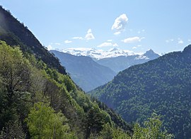
The landscape around Oulles
|
|
| Coordinates: 45°04′30″N 5°59′00″E / 45.075°N 5.9833°ECoordinates: 45°04′30″N 5°59′00″E / 45.075°N 5.9833°E | |
| Country | France |
| Region | Auvergne-Rhône-Alpes |
| Department | Isère |
| Arrondissement | Grenoble |
| Canton | Oisans-Romanche |
| Government | |
| • Mayor (2014–2020) | Stéphane Girard |
| Area1 | 11 km2 (4 sq mi) |
| Population (2011)2 | 12 |
| • Density | 1.1/km2 (2.8/sq mi) |
| Time zone | CET (UTC+1) |
| • Summer (DST) | CEST (UTC+2) |
| INSEE/Postal code | 38286 /38520 |
| Elevation | 728–2,559 m (2,388–8,396 ft) |
|
1 French Land Register data, which excludes lakes, ponds, glaciers > 1 km² (0.386 sq mi or 247 acres) and river estuaries. 2Population without double counting: residents of multiple communes (e.g., students and military personnel) only counted once. |
|
1 French Land Register data, which excludes lakes, ponds, glaciers > 1 km² (0.386 sq mi or 247 acres) and river estuaries.
Oulles is a commune in the Isère department in southeastern France. It is at 1,400 metres (4,600 ft) on the Taillefer massif.
...
Wikipedia


