Ouanne
| Ouanne | ||
|---|---|---|
| Commune | ||

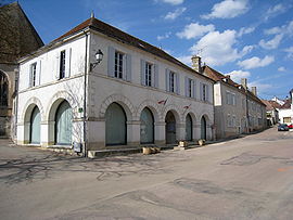
Town hall
|
||
|
||
| Coordinates: 47°39′45″N 3°25′09″E / 47.66250°N 3.4192°ECoordinates: 47°39′45″N 3°25′09″E / 47.66250°N 3.4192°E | ||
| Country | France | |
| Region | Bourgogne-Franche-Comté | |
| Department | Yonne | |
| Arrondissement | Auxerre | |
| Canton | Vincelles | |
| Government | ||
| • Mayor (2008–2014) | Remy Virtel | |
| Area1 | 38.20 km2 (14.75 sq mi) | |
| Population (2006)2 | 715 | |
| • Density | 19/km2 (48/sq mi) | |
| Time zone | CET (UTC+1) | |
| • Summer (DST) | CEST (UTC+2) | |
| INSEE/Postal code | 89283 /89560 | |
| Elevation | 226–371 m (741–1,217 ft) (avg. 314 m or 1,030 ft) |
|
|
1 French Land Register data, which excludes lakes, ponds, glaciers > 1 km² (0.386 sq mi or 247 acres) and river estuaries. 2Population without double counting: residents of multiple communes (e.g., students and military personnel) only counted once. |
||
1 French Land Register data, which excludes lakes, ponds, glaciers > 1 km² (0.386 sq mi or 247 acres) and river estuaries.
Ouanne is a commune in the Yonne department in Bourgogne-Franche-Comté in north-central France. Ouanne is also the name of an 84 km (52 mi) long river, taking its source in the vicinity, a right tributary of the Loing.
Existed at the time Gallo-Roman under the name of Odouna or Oduna. A Roman way carried out in Auxerre. The ancient station of Ouanne is known according to a marble fragment from the 3rd century preserved at the museum of Autun. The marble indicates the distances on the Roman way of Auxerre to Entrains-sur-Nohain. This way saw passing the armies of Pippin the Younger.
In 1790, Ouanne becomes chief town of canton but the number of cantons falls and the village is attached to Courson-les-Carrières. In 1972, the two communes of Ouanne and Chastenay join.
The river Ouanne has its source in the commune.
Inhabitants are known as Ouannais.
...
Wikipedia


