Ouadane
| Ouadane | |
|---|---|
| Commune and town | |

Old tower, Ouadane
|
|
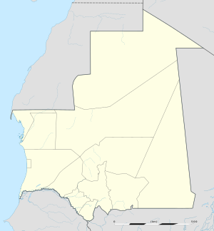
| Location in Mauritania | |
| Coordinates: 20°55′N 11°37′W / 20.917°N 11.617°WCoordinates: 20°55′N 11°37′W / 20.917°N 11.617°W | |
| Country |
|
| Region | Adrar Region |
| Elevation | 407 m (1,335 ft) |
| Population (2000) | |
| • Total | 3,695 |
| Official name | Ancient Ksour of Ouadane, Chinguetti, Tichitt and Oualata |
| Type | Cultural |
| Criteria | iii, iv, v |
| Designated | 1996 (20th session) |
| Reference no. | 750 |
| State Party |
|
| Region | Arab States |
Ouadane or Wādān (Arabic: وادان) is a small town in the desert region of central Mauritania, situated on the southern edge of the Adrar Plateau, 93 km northeast of Chinguetti. The town was a staging post in the trans-Saharan trade and for caravans transporting slabs of salt from the mines at Idjil. A Portuguese trading post was established in 1487, but was probably soon abandoned. The town declined from the sixteenth century and most of it now lies in ruins.
The old town, a World Heritage Site, though in ruins, is still substantially intact, while a small modern settlement lies outside its gate.
Ouadane is the closest town to the Richat Structure, a massive circular landmark visible from space.
The early history of Ouadane is uncertain but it is possible that the town prospered from the trans-Saharan gold trade. In the middle of the 11th century, the Arabic geographer al-Bakri described a trans-Saharan route that ran between Tamdoult near Akka in Morocco to Aoudaghost on the southern edge of the Sahara. This route was used for the transport of gold during the time of the Ghana Empire. In his account al-Bakri mentioned a series of place names but these have not been identified and historians have suggested several possible routes. In 1961 the French historian Raymond Mauny proposed a route that passed through Ouadane but Suzanne Daveau later argued in favour of a more direct route that crossed the Adrar escarpment to the east of the town. The volume of caravan traffic would have declined from the beginning of the 13th century when the oasis town of Oualata located 360 km to the east replaced Aoudaghost as the southern terminus of the trade route.
...
Wikipedia

