Adrar Region
|
Adrar ولاية آدرار |
|
|---|---|
| Region of Mauritania | |

Calotropis procera, Adrar desert
|
|
 |
|
| Coordinates: 20°30′N 10°04′W / 20.500°N 10.067°WCoordinates: 20°30′N 10°04′W / 20.500°N 10.067°W | |
| Country |
|
| Departments | |
| Capital | Atar |
| Area | |
| • Total | 235,000 km2 (91,000 sq mi) |
| Population (2013 census) | |
| • Total | 62,658 |
| • Density | 0.27/km2 (0.69/sq mi) |
| ISO 3166 code | MR-07 |
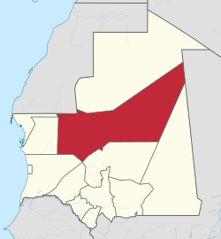
Adrar (Arabic: ولاية آدرار) is a large administrative region in Mauritania, named for the Adrar Plateau. The capital is Atar. Other major towns include Choum, Chinguetti and Ouadane. The region borders Western Sahara and the Mauritanian region of Tiris Zemmour to the north, Mali and the Mauritanian region of Hodh Ech Chargui to the east, the Mauritanian regions of Trarza and Tagant to the south and the Mauritanian region of Inchiri to the west.
As of 2013, the population of the region was 62,658, compared to 77,812 in 2011. There were 49.19 per cent females and 50.81 per cent males. As of 2008, the literacy rate for people aged 15 years and over was 50.30. The total net enrollment ratio at secondary level was 7.10 per cent. As of 2008, the activity rate was 48.20 and economic dependency ratio was 0.84.
As of 2013, the population of the region was 62,658, compared to 77,812 in 2011. There were 49.19 per cent females and 50.81 per cent males. As of 2008, the activity rate was 48.20 and economic dependency ratio was 0.84. The fraction of people working in government was 19.20 per cent, individual / household private was 12.60 per cent, other was 61.00 per cent, para public was 2.60 per cent, and private enterprise was 4.60 per cent. The Grand Total as of 2008 was 737.74. As of 2007, the number of tourist establishments in the region was 5. As of 2008, the Couples with children was 37.30 and Couples without children was 3.10. The proportion with extended family was 26.00 per cent and extended single-parent was 12.10 per cent, one-person was 6.60 per cent, and single-parent nuclear was 15.00 per cent.
As of 2008, the literacy rate for people aged 15 years and over was 50.30. The net enrollment ratio of girls for secondary level was 7.00 per cent, net enrollment ratio of boys for secondary level was 7.20 per cent, and total net enrollment ratio at secondary level was 7.10 per cent. As of 2013, the coverage rate of DPT3 Children From 0 to 11 Months in the region was 49.80 per cent, BGC vaccination was 52.60 and polio vaccination coverage was 49.80. As of 2008, the rate of household confirming the existence of public telephone in their neighbourhood or village was 69.24, rate of households benefiting from electricity post in their neighbourhood was 3.08 per cent, rate of households benefiting from health centre or health post in their neighbourhood was 2.29 per cent, and rate of households receiving the services public telephone was 2.68 per cent.
...
Wikipedia
