Ottawa South
|
|
|||
|---|---|---|---|

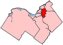
Ottawa South in relation to other electoral districts in Ottawa (2003 boundaries)
|
|||
| Federal electoral district | |||
| Legislature | House of Commons | ||
| MP |
Liberal |
||
| District created | 1987 | ||
| First contested | 1988 | ||
| Last contested | 2015 | ||
| District webpage | profile, map | ||
| Demographics | |||
| Population (2011) | 121,894 | ||
| Electors (2015) | 85,946 | ||
| Area (km²) | 73.26 | ||
| Pop. density (per km²) | 1,663.9 | ||
| Census divisions | Ottawa | ||
| Census subdivisions | Ottawa | ||
Coordinates: 45°21′33.372″N 75°39′51.69″W / 45.35927000°N 75.6643583°W
Ottawa South (French: Ottawa-Sud) is a federal electoral district in Ottawa, Ontario, Canada. It is represented in the House of Commons of Canada by David McGuinty, brother of former Premier of Ontario and Ottawa South MPP Dalton McGuinty. It has been held continuously by Liberal candidates since it was first contested in 1988. Ottawa South is a suburban, generally middle class riding, notable for having the highest Arab population in Ontario.
The riding is located within the city of Ottawa. It is bounded on the north and east by Highway 417, on the west by the Rideau River and on the south by a line beginning at the Rideau River and Hunt Club Road, then east to Limebank Road, south to Leitrim Road, east to the CP Rail line, north to Lester Road, then east along Lester and Davidson Road to Conroy Road, north to Hunt Club Road and east along Hunt Club and its prolongation to Highway 417. Neighbouring districts include Ottawa—Vanier to the north, Orléans to the east, Carleton to the south and Ottawa West—Nepean and Ottawa Centre to the west.
...
Wikipedia
