Otley
| Otley | |
|---|---|
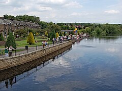
 The River Wharfe at Otley |
|
| Otley shown within West Yorkshire | |
| Population | 13,668 (2011) |
| OS grid reference | SE205455 |
| • London | 193 miles |
| Civil parish |
|
| Metropolitan borough | |
| Metropolitan county | |
| Region | |
| Country | England |
| Sovereign state | United Kingdom |
| Post town | OTLEY |
| Postcode district | LS21 |
| Dialling code | 01943 |
| Police | West Yorkshire |
| Fire | West Yorkshire |
| Ambulance | Yorkshire |
| EU Parliament | Yorkshire and the Humber |
| UK Parliament | |
Otley is a market town and civil parish at a bridging point on the River Wharfe in the City of Leeds metropolitan borough in West Yorkshire, England. Historically a part of the West Riding of Yorkshire, the population was 13,668 at the 2011 census. The town is in lower Wharfedale on the A660 which connects it to Leeds. The parish church (All Saints) has 7th-century origins.
Thomas Chippendale, the cabinetmaker, was born in the town and the painter J.M.W. Turner was a frequent visitor.
Otley's name is derived from Othe, Otho or Otta, a Saxon personal name and leah, a woodland clearing in Old English. It was recorded as Ottanlege in 972 and Otelai or Othelia in the Domesday Book of 1086. The name Chevin has close parallels to the early Brythonic Welsh term Cefn meaning ridge and may be a survival of the ancient Cumbric language.
There are pre-historic settlement finds alongside both sides of the River Wharfe and it is believed the valley has been settled at this site since the Bronze Age. There are Bronze Age carvings on rocks situated on top of The Chevin, one such example is the Knotties stone. West Yorkshire Geology Trust has reference to Otley Chevin and Caley Crags having a rich history of human settlement stretching back into Palaeolithic times. Flint tools, Bronze Age rock carvings and Iron Age earthworks have been found. In medieval times the forest park was used as common pasture land, as a source of wood and sandstones for buildings and walls.
...
Wikipedia

