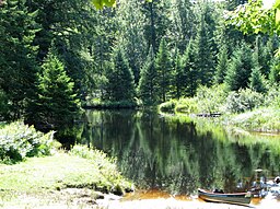
Oswegatchie River
| Otswegatchie River | |
| River | |
|
Oswegatchie River access on Inlet Road
|
|
| State | New York |
|---|---|
| Tributaries | |
| - left | West Branch Oswegatchie River, Black Lake |
| Mouth | Saint Lawrence River |
| - location | Ogdensburg, New York |
| - elevation | 242 ft (74 m) |
| - coordinates | 44°41′47″N 75°29′56″W / 44.6965°N 75.4990°WCoordinates: 44°41′47″N 75°29′56″W / 44.6965°N 75.4990°W |
| Length | 137 mi (220 km) |
| Basin | 1,592 sq mi (4,123 km2) |
The Oswegatchie River is a 137-mile-long (220 km) river in northern New York that flows from the Adirondack Mountains north to the Saint Lawrence River. The Oswegatchie River begins at Partlow Lake in Hamilton County, New York. The river continues through Cranberry Lake which was 'doubled in size' through construction of a dam in the late 1860s. The river continues from the dam to Gouverneur, to near Talcville in St. Lawrence County, where it joins the West Branch. Much of it is within Adirondack State Park. The city of Ogdensburg developed at the mouth of the river at its confluence with the St. Lawrence.
The mouth of the Oswegatchie River at the St. Lawrence River, was the site of a Jesuit mission, Fort de La Présentation, founded in 1749. Also a fur trading post, the village had 3,000 Onondaga by the 1750s, most of whom converted to Catholicism. They came to be known as the Oswegatchie; because of their converted status they were considered to be somewhat separate from the traditional Six Nations of the Iroquois.Oswegatchie may be Iroquois for "going or coming around a hill". William Bright says the name may come from the Onondaga word /oshewɛ'gaaji'/, meaning "black lumber," containing -shewɛ'gar-, "lumber", and -ji-, "be black". The Oswegatchie were considered by the British as one of the Seven Nations of Canada.
...
Wikipedia

