Osumi Islands

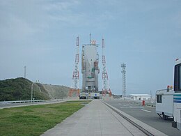
Tanegashima Space Center
|
|
| Map of Kagoshima Prefecture | |
| Geography | |
|---|---|
| Coordinates | 30°34′26″N 130°58′52″E / 30.57389°N 130.98111°E |
| Adjacent bodies of water | Pacific Ocean |
| Total islands | 9 |
| Administration | |
| Prefectures | Kagoshima |
| Demographics | |
| Population | 46500 (2010) |
| Ethnic groups | Japanese |
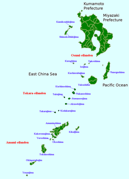
The Ōsumi Islands (大隅諸島 Ōsumi-shotō?) is an archipelago in the Nansei Islands, and are the northernmost group of the Satsunan Islands, which is in turn part of the Ryukyu Archipelago. The chain extends from the southern tip of Kyushu and Amami-Oshima. Administratively, the group belongs Kagoshima Prefecture, Japan.
The Ōsumi Islands are of volcanic origin and have a total area of approximately 1,030 square kilometres (400 sq mi). The highest elevation is Miyanouradake with a height of 1,935 metres (6,348 ft) on Yakushima. The climate is a humid subtropical climate (Köppen climate classification Cfa) with very warm summers and mild winters. Precipitation is high throughout the year, but is highest in the months of May, June and September.
The Ōsumi Islands have been settled since at least the Jōmon period. Burial sites on Tanegashima, namely the Yokomine and Hirota sites, attest to a uniquely well-developed Yayoi period culture at the end of the 4th century AD. The artifacts include magatama, an engraved pendant, and emblems with apparent writing.
Tanegashima and Yakushima are first mentioned in written documents of the Chinese Sui dynasty of the 6th century. Mention is made in the Japanese Shoku Nihongi under an entry for the year 699 of the islands of Tane, Yaku and Amami. The Ōsumi Islands formed ancient Tane Province during the Asuka period. The islands were often mentioned in the diaries of travelers between Tang-dynasty China and Nara period Japan.
...
Wikipedia

