Amami-Ōshima
|
Native name: 奄美大島, Amami Ōshima Nickname: Uushima |
|
|---|---|

Naze Port on Amami Ōshima
|
|
| Geography | |
| Location | East China Sea |
| Coordinates | 28°19′35″N 129°22′29″E / 28.32639°N 129.37472°ECoordinates: 28°19′35″N 129°22′29″E / 28.32639°N 129.37472°E |
| Archipelago | Amami Islands |
| Area | 712.39 km2 (275.06 sq mi) |
| Coastline | 461.1 km (286.51 mi) |
| Highest elevation | 694 m (2,277 ft) |
| Highest point | Yuwandake |
| Administration | |
| Prefectures | Kagoshima Prefecture |
| District | Ōshima District |
| Largest settlement | Amami (pop. 44,561) |
| Demographics | |
| Population | 73,000 (2013) |
| Ethnic groups | Japanese |
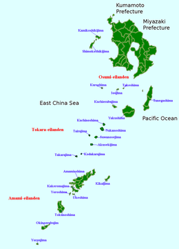
Amami Ōshima (奄美大島?, Okinawan: Uushima (ウーシマ?); Amami: Ushima (ウシマ?)) is one of the Satsunan Islands, and is the largest island within the Amami archipelago between Kyūshū and Okinawa.
The island, 712.35 km2 in area, has a population of approximately 73,000 people. Administratively it is divided into the city of Amami, the towns of Tatsugō, Setouchi, and the villages of Uken and Yamato in Kagoshima Prefecture. Much of the island is within the borders of the Amami Guntō Quasi-National Park.
Amami Ōshima is the seventh largest island in the Japanese archipelago (excluding the disputed Kuril Islands) after the four main islands, Okinawa Island and Sado Island. It is located approximately 380 kilometres (210 nmi) south of the southern tip of Kyūshū and 250 kilometres (130 nmi) north of Okinawa. The island is of volcanic origin, with Mount Yuwanda at 605 metres (1,985 ft) above sea level at its highest peak. The coast of the island is surrounded by a coral reef. It is surrounded by the East China Sea on the west and the Pacific Ocean on the east.
...
Wikipedia

