Oshawa (provincial electoral district)
|
|
|||
|---|---|---|---|

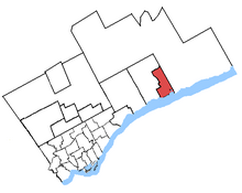
Oshawa in relation to other greater Toronto ridings
|
|||
| Provincial electoral district | |||
| Legislature | Legislative Assembly of Ontario | ||
| MPP |
New Democratic |
||
| First contested | 1955 | ||
| Demographics | |||
| Population (2006) | 116,881 | ||
| Electors (2011) | 87,638 | ||
| Area (km²) | 74 | ||
| Pop. density (per km²) | 1,579.5 | ||
| Census divisions | Durham | ||
| Census subdivisions | Oshawa | ||
Oshawa is a provincial electoral district in Ontario, Canada, that has been represented in the Legislative Assembly of Ontario since 1955.
It consists of the southern and eastern parts of the City of Oshawa south and east of a line drawn from west to east along King Street West, north along Oshawa Creek, east along Rossland Road West, north along Simcoe Street North and east along Winchester Road East. The riding includes the communities of Kedron and Taunton and the eastern part of North Oshawa. It has a population of 113,662 and an area of 74 km2.
In 1999, provincial ridings were defined to have the same borders as federal ridings.
Coordinates: 43°54′03″N 78°50′43″W / 43.9009°N 78.8454°W
...
Wikipedia
