Osceola, Indiana
| Osceola, Indiana | |
|---|---|
| Town | |

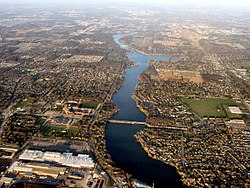
Osceola, with St. Joe River flowing west to Mishawaka (bottom). Baugo Bay is in the upper right. Elkhart is in the distance.
|
|
 Location of Osceola in the state of Indiana |
|
| Coordinates: 41°39′49″N 86°4′31″W / 41.66361°N 86.07528°WCoordinates: 41°39′49″N 86°4′31″W / 41.66361°N 86.07528°W | |
| Country | United States |
| State | Indiana |
| County | St. Joseph |
| Township | Penn |
| Area | |
| • Total | 1.37 sq mi (3.55 km2) |
| • Land | 1.36 sq mi (3.52 km2) |
| • Water | 0.01 sq mi (0.03 km2) |
| Elevation | 735 ft (224 m) |
| Population (2010) | |
| • Total | 2,463 |
| • Estimate (2012) | 2,456 |
| • Density | 1,811.0/sq mi (699.2/km2) |
| Time zone | Eastern (EST) (UTC-5) |
| • Summer (DST) | EDT (UTC-4) |
| ZIP code | 46561 |
| Area code(s) | 574 |
| FIPS code | 18-57114 |
| GNIS feature ID | 452723 |
Osceola is a town in Penn Township, St. Joseph County, in the U.S. state of Indiana. The population was 2,463 at the 2010 Census. It is part of the South Bend–Mishawaka, IN-MI, Metropolitan Statistical Area.
Osceola was platted in 1837. The town was named after Osceola, leader of the Seminole. A post office has been in operation at Osceola since 1854.
Osceola is located at 41°39′49″N 86°4′31″W / 41.66361°N 86.07528°W (41.663474, -86.075205).
According to the 2010 census, Osceola has a total area of 1.37 square miles (3.55 km2), of which 1.36 square miles (3.52 km2) (or 99.27%) is land and 0.01 square miles (0.03 km2) (or 0.73%) is water. Osceola is also home to Ferrettie/Baugo Creek County Park, a 214 acre park with an extensive trail network along Baugo Creek.
Located in the Penn-Harris-Madison School Corporation, Osceola spans both sides of the St. Joseph River, although the majority is on the south side. Osceola is divided once again by the railroad.
As of the census of 2010, there were 2,463 people, 905 households, and 672 families residing in the town. The population density was 1,811.0 inhabitants per square mile (699.2/km2). There were 979 housing units at an average density of 719.9 per square mile (278.0/km2). The racial makeup of the town was 95.5% White, 1.4% African American, 0.2% Native American, 0.7% Asian, 0.2% Pacific Islander, 0.3% from other races, and 1.7% from two or more races. Hispanic or Latino of any race were 2.1% of the population.
...
Wikipedia
