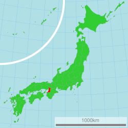
Osaka prefecture
|
Osaka Prefecture 大阪府 |
|||
|---|---|---|---|
| Prefecture | |||
| Japanese transcription(s) | |||
| • Japanese | 大阪府 | ||
| • Rōmaji | Ōsaka-fu | ||
|
|||
 |
|||
| Coordinates: 34°41′11″N 135°31′12″E / 34.68639°N 135.52000°ECoordinates: 34°41′11″N 135°31′12″E / 34.68639°N 135.52000°E | |||
| Country | Japan | ||
| Region | Kansai | ||
| Island | Honshu | ||
| Capital | Osaka | ||
| Government | |||
| • Governor | Ichirō Matsui | ||
| Area | |||
| • Total | 1,899.28 km2 (733.32 sq mi) | ||
| Area rank | 46th | ||
| Population (January 1, 2012) | |||
| • Total | 8,864,228 | ||
| • Rank | 3rd | ||
| • Density | 4,700/km2 (12,000/sq mi) | ||
| ISO 3166 code | JP-27 | ||
| Districts | 5 | ||
| Municipalities | 43 | ||
| Flower |
Japanese apricot (Prunus mume) Primrose (Primula sieboldii) |
||
| Tree | Ginkgo tree (Ginkgo biloba) | ||
| Bird | Bull-headed shrike (Lanius bucephalus) | ||
| Website | www |
||
Osaka Prefecture (大阪府 Ōsaka-fu?) is a prefecture located in the Kansai region on Honshu, the main island of Japan. The capital is the city of Osaka. It is the center of Osaka-Kobe-Kyoto area. Osaka is one of the two "urban prefectures" (府 fu?) of Japan, Kyoto being the other (Tokyo became a "metropolitan prefecture", or to, in 1941).
Until the Meiji Restoration, the area of Osaka prefecture was known as Kawachi, Izumi, and Settsu provinces.
Osaka Prefecture was created on June 21, 1868, at the very beginning of the Meiji era. During the instigation of Fuhanken Sanchisei in 1868, the prefecture received its suffix fu, designating it as an urban prefecture.
On September 1, 1956, the city of Osaka was promoted to a city designated by government ordinance and thereby divided into 24 wards.
...
Wikipedia


