Orizona
| Orizona | |
|---|---|
| Municipality | |
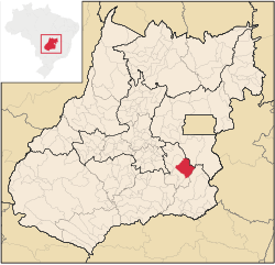
 Location in Goiás state |
|
| Location in Brazil | |
| Coordinates: 17°02′02″S 48°17′52″W / 17.03389°S 48.29778°WCoordinates: 17°02′02″S 48°17′52″W / 17.03389°S 48.29778°W | |
| Country |
|
| Region | Central-West Region |
| State | Goiás |
| Microregion | Pires do Rio Microregion |
| Area | |
| • Total | 1,972.8 km2 (761.7 sq mi) |
| Elevation | 806 m (2,644 ft) |
| Population (2007) | |
| • Total | 14,374 |
| • Density | 7.3/km2 (19/sq mi) |
| Time zone | BRT/BRST (UTC-3/-2) |
| Postal code | 75280-000- |
| Website | www |
Orizona is a municipality in Goiás state, Brazil.
Orizona is 138 km from the state capital of Goiânia, 200 km from Brasília, 150 from Catalão and 260 from Uberlândia, which is located in the rich Triângulo Mineiro of Minas Gerais. It is part of the Pires do Rio Microregion. See Citybrazil for all the regions.
Highway connections from Goiânia are made by BR-357 / GO-010 / Bonfinópolis / Vianópolis / GO-330. See Sepin for all the distances.
It borders Silvânia, Luziânia, Cristalina, Pires do Rio, Ipameri, Urutaí and Vianópolis.
Orizona was founded by Joaquim Fernandes de Castro and José Pereira Cardoso in 1850 when they started construction of a chapel on the banks of the Ribeirão Santa Bárbara, a tributary of the Corumbá River. In 1890 the settlement became a district called Capela dos Correias, and in 1909 it became a city called Campo Formoso. In 1943 the name was changed to Orizona, from "oriza", meaning rice, and "zona", meaning region—Region of Rice. The name was chosen in a public contest, in which 42 people voted. It was suggested by Dr. Raphael Leme Franco, other names proposed were Caruaba, Coema, Manhana, Orizona, Porangatu, Potira, Jubara and Oriza. See Prefeitura de Orizona for the history.
...
Wikipedia

