Ontario Highway 90
| Highway 90 | |||||||||||||
|---|---|---|---|---|---|---|---|---|---|---|---|---|---|
 |
|||||||||||||
| Route information | |||||||||||||
| Maintained by the Ministry of Transportation of Ontario | |||||||||||||
| Length: | 19.0 km (11.8 mi) | ||||||||||||
| Existed: | October 6, 1937 – January 1, 1998 | ||||||||||||
| Major junctions | |||||||||||||
| West end: | Camp Borden Road in Angus (continues south as Simcoe County Road 10) |
||||||||||||
| Highway 131 | |||||||||||||
| East end: |
|
||||||||||||
| Location | |||||||||||||
| Major cities: | Barrie | ||||||||||||
| Towns: | Angus | ||||||||||||
| Highway system | |||||||||||||
|
|||||||||||||
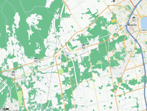
King's Highway 90, commonly referred to as Highway 90, was a provincially maintained highway in the Canadian province of Ontario. The route connected Barrie with the town of Angus and CFB Borden. The highway was designated in 1937. During the early 1960s, the highway was realigned within Barrie in order to have it interchange with Highway 400; originally the route followed Tiffin Street. At the beginning of 1998, the entire highway was transferred to the City of Barrie and Simcoe County; it is now known as Simcoe County Road 90.
Today, the former routing of Highway 90 is known as Dunlop Street within Barrie and Simcoe County Road 90 outside of the city. The route begins at a split between Cambrai Road, which provides access to Camp Borden, and Simcoe County Road 10, which continues south to Alliston and Tottenham. The four lane Simcoe County Road 90 progresses north through the centre of Angus. North of the Barrie Collingwood Railway overhead, it acts as the principal commercial strip for the town. North of Angus, the highway makes a broad 90 degree turn to the east and skims the southern edge of the Minesing Wetlands, an internationally significant bog.
East of the swamp, the road enters Essa, where it intersects the Sunnidale Road (Simcoe County Road 40). From there to Barrie, the highway passes through a largely rural area. It intersects former Highway 131, now Simcoe County Road 27, then enters Barrie at Miller Drive, curving northeast. East of Ferndale Drive, the route crosses Highway 400 at Exit 96. Shortly thereafter, as it approaches the waterfront of Kempenfelt Bay, the route ends at High Street in downtown Barrie.
...
Wikipedia

