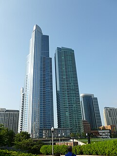
One Museum Park West
| The Grant | |
|---|---|

One Museum Park (on the left) and The Grant (on the right)
|
|
| Former names | One Museum Park West |
| General information | |
| Status | Complete |
| Type | Residential |
| Location |
Roosevelt Road and Indiana Avenue Chicago, Illinois |
| Coordinates | 41°52′02″N 87°37′20″W / 41.867100°N 87.622250°WCoordinates: 41°52′02″N 87°37′20″W / 41.867100°N 87.622250°W |
| Construction started | March 2007 |
| Opening | July 2010 |
| Height | |
| Tip | 181 metres (594 ft) |
| Roof | 180.09 metres (590.8 ft) |
| Top floor | 161.89 metres (531.1 ft) |
| Technical details | |
| Floor count | 54 |
| Floor area | 92,987 m2 (1,000,900 sq ft) |
| Design and construction | |
| Architect | Pappageorge/Haymes, Ltd. |
The Grant (formerly One Museum Park West) is the companion structure to One Museum Park in the Near South Side community area (neighborhood) in Chicago, Illinois, USA. It is located at the north end of the Central Station development.
Museum Park is a complex of multiple residential towers within the Central Station development at the southern edge of Grant Park, across Lake Shore Drive from Chicago's Museum Campus. Construction of The Grant followed the 62-story One Museum Park, directly to the east. In 2006, the Prairie District Neighborhood Alliance, a non-profit organization was formed to provide representation for thousands of South Loop residents, including the Prairie District, Central Station and Museum Park, Motor Row, the South Michigan Ave Corridor, as well as other areas of the Near South Side.
In July 2012, the building was acquired by New York-based Related Companies along with the former 1600 Museum Park and Museum Park Place 2 and later renamed The Grant, Adler Place and Harbor View. As of February 2013, 238 units in the building remained unsold.
The building is zoned to schools in the Chicago Public Schools.
Construction photograph (2007-05-28)
Early construction from Sears Tower (2008-06-20)
Early construction close-up (2008-07-13)
...
Wikipedia
