
Olpe, Germany
| Olpe | ||
|---|---|---|

Olpe Town Hall, one of the tallest buildings in the town
|
||
|
||

Olpe
|
||
|
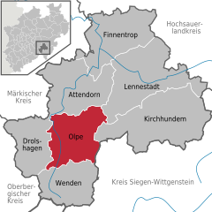
Location of Olpe within Olpe district
  |
||
| Coordinates: 51°01′N 07°50′E / 51.017°N 7.833°ECoordinates: 51°01′N 07°50′E / 51.017°N 7.833°E | ||
| Country | Germany | |
| State | North Rhine-Westphalia | |
| Admin. region | Arnsberg | |
| District | Olpe | |
| Government | ||
| • Mayor | Horst Müller (CDU) | |
| Area | ||
| • Total | 85.6 km2 (33.1 sq mi) | |
| Population (2015-12-31) | ||
| • Total | 24,757 | |
| • Density | 290/km2 (750/sq mi) | |
| Time zone | CET/CEST (UTC+1/+2) | |
| Postal codes | 57462 | |
| Dialling codes | 02761, 02722, 02764 | |
| Vehicle registration | OE | |
| Website | www.olpe.de | |

Olpe is a town situated in the foothills of the Ebbegebirge in North Rhine-Westphalia, roughly 60 km east of Cologne and 20 km northwest of Siegen. It is part of the Regierungsbezirk of Arnsberg and is the seat of the district of Olpe.
Olpe lies in the Sauerland on the southern edge of the Ebbegebirge Nature Park. In the town’s north lies South Westphalia’s biggest reservoir, the Biggesee.
The highest mountains are:
The inner town is ringed by the following hills:
The municipal area also has a few rivers or brooks that all empty into the Biggesee:
Other rivers in the municipal area:
The Veischedebach does not empty into the Biggesee, but rather into the Lenne near Grevenbrück.
Olpe is found in a broad stretch of hilly country. In the town’s north, the slopes are steeper and the dales narrower (for instance near the centres of Rhode and Neger); in the south, the hills have soft knolls and the dales are more spacious. There are also no plateaux there.
The area around the Biggesee and the main town of Olpe, as the Bundesamt für Bauwesen und Raumordnung (“Federal Office for Construction and Regional Planning”) sees them, are included in the Mittelbiggebergland (“Middle Bigge Mountain Land”), while the eastern and southern portions of the municipal area are designated Südsauerländer Rothaarvorhöhen (“South Sauerland Rothaar Foothills”).
The municipal area is an integral part of the Rheinisches Schiefergebirge (“Rhenish Slate Mountains”).
The underlying minerals around the middle and upper Bigge are made up to a considerable degree of schistose, partly chalky clays and coarse clay. Furthermore, there are sandstones with quartzitelike characteristics.
Olpe’s municipal area has a total area of 86 km². Its greatest extent is in both the north-south and east-west directions, reaching 11 km. Olpe’s lowest point is the Biggesee lying at 307.5 m above sea level, and its highest point is the Engelsberg near Neuenkleusheim at 589 m above sea level.
...
Wikipedia