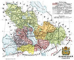
Olonets Krai
| Olonets Governorate Олонецкая губернiя Aunuksen kuvernementti |
|||||
| Governorate of Russian Empire, Soviet Russia | |||||
|
|||||
| Capital | Petrozavodsk | ||||
| History | |||||
| • | Established | September 21, 1801 | |||
| • | Disestablished | September 18, 1922 | |||
| Area | |||||
| • | (1897) | 2,701.65 km2(1,043 sq mi) | |||
| Population | |||||
| • | (1897) | 364,156 | |||
| Density | 134.8 /km2 (349.1 /sq mi) | ||||
| Political subdivisions | uezds: 7 (1922), 4 | ||||
The Olonets Governorate or Government of Olonets was a guberniya (governorate) of north-western Imperial Russia, extending from Lake Ladoga almost to the White Sea, bounded west by Finland, north and east by Arkhangelsk and Vologda, and south by Novgorod and Saint Petersburg. The area was 57,422 m², of which 6,794 m² were covered by lakes.
Its north-western portion belonged orographically and geologically to the Finland region; it is thickly dotted with hills reaching 1,000 ft. in altitude, and diversified by numberless smaller ridges and hollows running from northwest to south-east. The rest of the governorate was a flat plateau sloping towards the marshy lowlands of the south. The geological structure was very varied. Granites, syenites, and diorites, covered with Laurentian metamorphic slates, occurred extensively in the north-west. Near Lake Onega they were overlain with Devonian sandstones and limestones, yielding marble and sandstone for building; to the south of that lake carboniferous limestones and clays made their appearance. The whole was sheeted with boulder-clay, the bottom moraine of the great ice-sheet of the last glacial period. The entire region bears traces of glaciation, either in the shape of scratchings and elongated grooves on the rocks, or of eskers (asar, selgas) running parallel to the glacial striations.
...
Wikipedia


