Olmsted County, Minnesota
| Olmsted County, Minnesota | ||
|---|---|---|

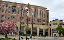
Olmsted County Government Center
|
||
|
||
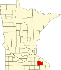
 Location in the U.S. state of Minnesota |
||
 Minnesota's location in the U.S. |
||
| Founded | February 20, 1855 | |
| Named for | David Olmsted | |
| Seat | Rochester | |
| Largest city | Rochester | |
| Area | ||
| • Total | 655 sq mi (1,696 km2) | |
| • Land | 653 sq mi (1,691 km2) | |
| • Water | 1.5 sq mi (4 km2), 0.2% | |
| Population (est.) | ||
| • (2016) | 153,102 | |
| • Density | 221/sq mi (85/km²) | |
| Congressional district | 1st | |
| Time zone | Central: UTC-6/-5 | |
| Website | www |
|
Olmsted County is a county located in the U.S. state of Minnesota. As of the 2010 census, the population was 144,248. Its county seat and largest city is Rochester. The county was founded in 1855 and named for David Olmsted, a member of the first territorial council and the first mayor of St. Paul.
Olmsted County is part of the Rochester, MN Metropolitan Statistical Area.
According to the U.S. Census Bureau, the county has a total area of 655 square miles (1,700 km2), of which 653 square miles (1,690 km2) is land and 1.5 square miles (3.9 km2) (0.2%) is water.
It is one of four counties in Minnesota that does not have any natural lakes (the other three being Mower, Pipestone, and Rock).
Though Olmsted County does not have any natural lakes, it does have six reservoirs created by dams.
As of the census of 2000, there were 124,277 people, 47,807 households, and 32,317 families residing in the county. The population density was 190 people per square mile (73/km²). There were 49,422 housing units at an average density of 76 per square mile (29/km²). The racial makeup of the county was 90.33% White, 2.68% Black or African American, 0.26% Native American, 4.27% Asian, 0.03% Pacific Islander, 0.92% from other races, and 1.51% from two or more races. 2.38% of the population were Hispanic or Latino of any race. The ancestral makeup of the county was 33.7% German, 16.1% Norwegian, 8.0% Irish and 5.2% English.
...
Wikipedia
