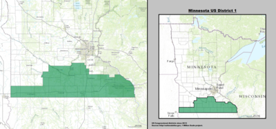
Minnesota's 1st congressional district
| Minnesota's 1st congressional district | |
|---|---|

Minnesota's 1st congressional district - since January 3, 2013.
|
|
| Current Representative | Tim Walz (D–Mankato) |
| Area | 13,322 sq mi (34,500 km2) |
| Distribution |
|
| Population (2000) | 614,935 |
| Median income | 40,941 |
| Ethnicity |
|
| Cook PVI | R+5 |
|
|
Minnesota's 1st congressional district extends across southern Minnesota from the border with South Dakota to the border with Wisconsin. The First District is primarily a rural district built on a strong history of agriculture, although this is changing rapidly due to strong population growth in Rochester and surrounding communities. The First District is also home to several of Minnesota's major mid-sized cities, including Rochester, Mankato, Winona, Austin, Owatonna, Albert Lea, New Ulm, and Worthington. This district is currently represented by U.S. Congressman Tim Walz (Mankato) from the Democratic-Farmer-Labor Party.
From early statehood until the latest redistricting after the 2000 census, the first district covered only southeast Minnesota. During the 20th century it was generally considered solidly Republican, though in recent years this is changing. In 2004, John Kerry received 48% of the vote in this Congressional district. Two years later, in 2006, Republican Representative Gil Gutknecht was defeated by Democrat Tim Walz. The district leans slightly Republican with a CPVI of R + 1.
2016
Coordinates: 43°53′56″N 93°42′42″W / 43.89889°N 93.71167°W
...
Wikipedia
