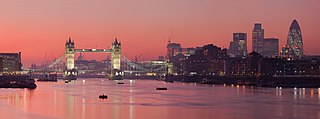
Old Father Thames
| Thames | |
| River | |
|
The Thames in London
|
|
| Country | England |
|---|---|
| Counties | Gloucestershire, Wiltshire, Oxfordshire, Berkshire, Buckinghamshire, Surrey, Middlesex, London, Kent, Essex |
| Towns/Cities | Cricklade, Lechlade, Oxford, Abingdon, Wallingford, Reading, Henley-on-Thames, Marlow, Maidenhead, Windsor, Staines-upon-Thames, Walton-on-Thames, Kingston upon Thames, Teddington, Richmond, London, London |
| Source | |
| - location | Thames Head, Gloucestershire, UK |
| - elevation | 110 m (361 ft) |
| - coordinates | 51°41′39″N 2°01′47″W / 51.694262°N 2.029724°W |
| Mouth | Thames Estuary, North Sea |
| - location | Southend-on-Sea, Essex, UK |
| - elevation | 0 m (0 ft) |
| - coordinates | 51°29′56″N 0°36′31″E / 51.4989°N 0.6087°ECoordinates: 51°29′56″N 0°36′31″E / 51.4989°N 0.6087°E |
| Length | 346 km (215 mi) |
| Basin | 12,935 km2 (4,994 sq mi) |
| Discharge | for London |
| - average | 65.8 m3/s (2,324 cu ft/s) |
| - max | 370 m3/s (13,066 cu ft/s) |
| Discharge elsewhere (average) | |
| - entering Oxford | 17.6 m3/s (622 cu ft/s) |
| - leaving Oxford | 24.8 m3/s (876 cu ft/s) |
| - Reading | 39.7 m3/s (1,402 cu ft/s) |
| - Windsor | 59.3 m3/s (2,094 cu ft/s) |
|
Map of the Thames within southern England
|
|
The River Thames (/tɛmz/ TEMZ) is a river that flows through southern England, most notably through London. At 215 miles (346 km), it is the longest river entirely in England and the second longest in the United Kingdom, after the River Severn. It also flows through Oxford (where it is called Isis), Reading, Henley-on-Thames and Windsor. The lower reaches of the river are called the Tideway, derived from its long tidal reach up to Teddington Lock. It rises at Thames Head in Gloucestershire, and flows into the North Sea via the Thames Estuary. The Thames drains the whole of Greater London.
Its tidal section, reaching up to Teddington Lock, includes most of its London stretch and has a rise and fall of 7 metres (23 ft). Running through some of the driest parts of mainland Britain and heavily abstracted for drinking water, the Thames' discharge is low considering its length and breadth: the Severn has a discharge almost twice as large on average despite having a smaller drainage basin. In Scotland, the Tay achieves more than double the average discharge from a drainage basin that is 60% smaller.
...
Wikipedia


