Olang
| Olang | |
|---|---|
| Comune | |
| Gemeinde Olang Comune di Valdaora |
|

Olang
|
|
| Location of Olang in Italy | |
| Coordinates: 46°46′N 12°2′E / 46.767°N 12.033°ECoordinates: 46°46′N 12°2′E / 46.767°N 12.033°E | |
| Country | Italy |
| Region | Trentino-Alto Adige/Südtirol |
| Province / Metropolitan city | South Tyrol (BZ) |
| Frazioni | Geiselsberg (Sorafurcia), Mitterolang (Valdaora di Mezzo), Niederolang (Valdaora di Sotto), Oberolang (Valdaora di Sopra) |
| Government | |
| • Mayor | Georg Reden |
| Area | |
| • Total | 49.0 km2 (18.9 sq mi) |
| Population (Nov. 2010) | |
| • Total | 3,065 |
| • Density | 63/km2 (160/sq mi) |
| Demonym(s) | German: Olanger Italian: di Valdaora |
| Time zone | CET (UTC+1) |
| • Summer (DST) | CEST (UTC+2) |
| Postal code | 39030 |
| Dialing code | 0474 |
| Website | Official website |
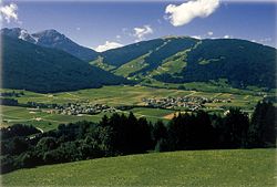
Olang (German pronunciation: [ˈoˑlaŋ]; Italian: Valdaora [valˈdaːora]) is a comune (municipality) in South Tyrol in northern Italy, located about 60 kilometres (37 mi) northeast of the city of Bolzano.
As of 30 November 2010, it had a population of 3,065 and an area of 49.0 square kilometres (18.9 sq mi).
Olang borders the following municipalities: Bruneck, Mareo, Prags, Rasen-Antholz, and Welsberg-Taisten.
The municipality of Olang contains the frazioni (subdivisions, mainly villages and hamlets) Geiselsberg (Sorafurcia), Mitterolang (Valdaora di Mezzo), Niederolang (Valdaora di Sotto) and Oberolang (Valdaora di Sopra).
The emblem is argent a bend vert on which are represented three cart’s wheels. The wheels symbolize the villages of Mitter, Ober and Nieder and their disposition in the valley. The emblem was granted in 1968.
According to the 2011 census, 96.47% of the population speak German, 3.18% Italian and 0.34% Ladin as first language.
...
Wikipedia

