Oklahoma State Highway 3
| State Highway 3 | ||||
|---|---|---|---|---|
 |
||||
| Route information | ||||
| Maintained by ODOT | ||||
| Length: | 615.0 mi (989.7 km) | |||
| Existed: | 1939 – present | |||
| Major junctions | ||||
| West end: |
|
|||
|
|
||||
| East end: |
|
|||
| Highway system | ||||
|
Oklahoma State Highway System
|
||||
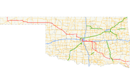
State Highway 3, also abbreviated as SH-3 or OK-3, is a highway maintained by the U.S. state of Oklahoma. Traveling diagonally through Oklahoma, from the Panhandle to the far southeastern corner of the state, SH-3 is the longest state highway in the Oklahoma road system, at a total length of 615 miles (990 km) via SH-3E (see below).
Highway 3 begins at the Colorado state line 19 mi (31 km) north of Boise City, Oklahoma. At this terminus, it is concurrent with US-287/US-385. It remains concurrent with the two U.S. Routes until reaching Boise City, where it encounters a traffic circle which contains five other highways. After the circle, US-385 splits off, and SH-3 overlaps US-287, US-56, US-64, and US-412, though US-56 and US-287 both split off within the next 8 miles (13 km).
In Guymon, US-64 splits off. At Elmwood, US-270 joins US-412, coming from a concurrency with State Highway 23. SH-3 remains concurrent with US-270 through Watonga. In Seiling, US-183 leaves the concurrency but is quickly replaced by U.S. Highway 281. SH-33 joins the roadbed 20 miles (32 km) later.
...
Wikipedia

