U.S. Highway 270 (Oklahoma)
| U.S. Route 270 | |
|---|---|
 |
|
| Route information | |
| Auxiliary route of US 70 | |
| Length: | 643 mi (1,035 km) |
| Existed: | 1930 – present |
| Major junctions | |
| West end: |
|
| East end: |
|
| Location | |
| States: | Kansas, Oklahoma, Arkansas |
| Highway system | |
| U.S. Highway 270B | |
|---|---|
| Location: | Hot Springs, Ark. |
| Length: | 9.4 mi (15.1 km) |
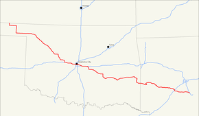
U.S. Route 270 (US 270) is a spur of U.S. Route 70. It runs for 643 miles (1,035 km) from Liberal, Kansas at U.S. Route 54 to White Hall, Arkansas at Interstate 530 and U.S. Route 65. It passes through the states of Arkansas, Oklahoma, and Kansas. It goes through the cities of Oklahoma City, Oklahoma, Hot Springs, Arkansas, and McAlester, Oklahoma.
US 270 begins in the southeast part of Liberal, Kansas, at an intersection with US 83 (running north–south through the intersection) and US 54. US 270 follows the south leg of this intersection, following US 83 south. US 270 only spends 3 miles (4.8 km) in Kansas before crossing into Oklahoma. Seward County is the only Kansas county that US-270 serves.
US 270 enters Oklahoma in Beaver County, the eastern third of the Oklahoma Panhandle. From here it continues east along US 64, then south towards Beaver, the county seat, along SH-23. South of Beaver, the road joins with US 412 (OK) and SH-3, the latter of which US 270 will overlap with through most of northwest Oklahoma. After leaving the Panhandle and picking up US 183 near Fort Supply, the highways turn southwest towards Woodward. US 412 splits away in Woodward. US 270, concurrent with US 183 and SH-3, proceed southeast toward Seiling. West of Seiling, US 183 splits off to the south, but in Seiling, it is replaced by US 281. The routes continue southwest to Watonga, where US 270/281 turn south along SH-8, while SH-3 continues due east to concur with SH-33. In Geary, US 270 splits off on an independent alignment, looping through Calumet before joining with Interstate 40.
...
Wikipedia

