Watonga, Oklahoma
| Watonga, Oklahoma | |
|---|---|
| City | |
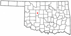
 Location of Watonga, Oklahoma |
|
| Coordinates: 35°50′57″N 98°24′42″W / 35.84917°N 98.41167°WCoordinates: 35°50′57″N 98°24′42″W / 35.84917°N 98.41167°W | |
| Country | United States |
| State | Oklahoma |
| County | Blaine |
| Area | |
| • Total | 4.08 sq mi (10.58 km2) |
| • Land | 4.07 sq mi (10.55 km2) |
| • Water | 0.01 sq mi (0.03 km2) |
| Elevation | 1,516 ft (462 m) |
| Population (2010) | |
| • Total | 5,111 |
| • Density | 1,255/sq mi (484.5/km2) |
| Time zone | Central (CST) (UTC-6) |
| • Summer (DST) | CDT (UTC-5) |
| ZIP code | 73772 |
| Area code(s) | 580 |
| FIPS code | 40-78950 |
| GNIS feature ID | 1099426 |
| Website | www |
Watonga is a city in Blaine County, Oklahoma, United States. It is seventy miles northwest of Oklahoma City. The population was 5,111 at the 2010 census. It is the county seat of Blaine County.
Watonga is located on former Cheyenne and Arapaho Indian Reservation lands that were allotted to individual tribal members and the excess opened to white settlers in the Land Run of 1892. Watonga is named after Arapaho Chief Watonga whose name means "Black Coyote".
The town began as a tent city on April 19, 1892. A post office opened in Watonga during the same year. However, the first railroad line through Watonga was not built until 1901-02, when the Enid and Anadarko Railway (later the Chicago, Rock Island and Pacific Railway) constructed a line from Guthrie.
Watonga is located in central Blaine County at 35°50′57″N 98°24′42″W / 35.84917°N 98.41167°W (35.849249, -98.411591). According to the United States Census Bureau, the city has a total area of 4.1 square miles (10.6 km2), of which 0.012 square miles (0.03 km2), or 0.28%, is water.
As of the 2000 census[update], there were 4,658 people, 1,273 households, and 858 families residing in the city. The population density was 1,703.1 people per square mile (656.4/km²). There were 1,507 housing units at an average density of 551.0 per square mile (212.4/km²). The racial makeup of the city was 61.19% White, 15.33% African American, 8.24% Native American, 1.55% Asian, 2.02% Pacific Islander, 4.89% from other races, and 6.78% from two or more races. Hispanic or Latino of any race were 11.91% of the population.
...
Wikipedia
