Okinotorishima
| Native name: 沖ノ鳥, Okinotori-shima | |
|---|---|
 |
|
| Geography | |
| Location | Philippine Sea, Pacific Ocean |
| Coordinates | 20°25′N 136°05′E / 20.417°N 136.083°E |
| Total islands | 1 atoll with 2 islets |
| Area | 0.008482 km2 (0.003275 sq mi) |
| Highest elevation | 1.5 m (4.9 ft) |
| Highest point | unnamed point |
| Administration | |
|
Japan
|
|
| Prefectures | Tokyo |
| Village | Ogasawara |
| Demographics | |
| Population | 0 |
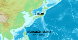
The Okinotori Islands (沖ノ鳥島 Okinotori-shima?) is a Japanese uninhabited atoll with a total area of 8,482 m2 (2.096 acres). Its dry land area is mostly made up by three concrete encasings and there is a 100 by 50 m (330 by 160 ft) platform in the lagoon housing a research station. It is located on the Palau-Kyushu Ridge in the Philippine Sea, 534 km (332 mi) southeast of Oki Daitō and 567 km (352 mi) west-southwest of Minami Iwo Jima of the Ogasawara Islands or 1,740 km (1,080 mi) south of Tokyo, Japan. The atoll is the southernmost part of Japan and the only Japanese territory in the tropics.
Japan claims the atoll is significant enough for Japan to have a 200-mile exclusive economic zone (EEZ) around the atoll, but the People's Republic of China, South Korea, and the Republic of China (Taiwan) dispute the Japanese EEZ saying that the atoll does not meet the definition of an island under the United Nations Convention on the Law of the Sea.
The English meaning of the name is "remote bird islands".
The atoll has multiple designations in English (Okinotori coral reefs, Okinotori Islands). Its original name was Parece Vela,Spanish for "it looks like a sail" (alluding to the original appearance of the reef). This name has been retained in English as well, especially to designate the geological formations of the islets.
...
Wikipedia

