Oestrich-Winkel
| Oestrich-Winkel | ||
|---|---|---|

Aerial view of Oestrich and Rhine river
|
||
|
||
| Coordinates: 50°00′N 08°00′E / 50.000°N 8.000°ECoordinates: 50°00′N 08°00′E / 50.000°N 8.000°E | ||
| Country | Germany | |
| State | Hesse | |
| Admin. region | Darmstadt | |
| District | Rheingau-Taunus-Kreis | |
| Government | ||
| • Mayor | Michael Heil | |
| Area | ||
| • Total | 59.53 km2 (22.98 sq mi) | |
| Elevation | 84 m (276 ft) | |
| Population (2015-12-31) | ||
| • Total | 11,632 | |
| • Density | 200/km2 (510/sq mi) | |
| Time zone | CET/CEST (UTC+1/+2) | |
| Postal codes | 65375 | |
| Dialling codes | 06723 | |
| Vehicle registration | RÜD, SWA | |
| Website | www.oestrich-winkel.de | |
Oestrich-Winkel (German pronunciation: [ˈøːstʁɪç ˈvɪŋkəl]) is a town with roughly 12,000 inhabitants in the Rheingau-Taunus-Kreis in the Regierungsbezirk of Darmstadt in Hesse, Germany.
Oestrich-Winkel, which culturally belongs to the Rheingau region, lies on the Rhine River, 19 km westsouthwest of Wiesbaden and 17 km west of Mainz. It is, as a part of the Rheingau wine region, the largest wine growing town of Hesse.
The coordinates 50°N, 8°E lie right in the stadtteil of Winkel, whose name, coincidentally, is German for “angle”.
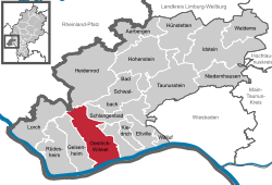
Oestrich-Winkel borders in the north on the town of Lorch and the municipalities of Welterod (Rhein-Lahn-Kreis in Rhineland-Palatinate), Heidenrod and Schlangenbad; in the east on the town of Eltville; in the south, across the Rhine, on the town of Ingelheim (Mainz-Bingen district in Rhineland-Palatinate) and in the west on the town of Geisenheim.
Oestrich-Winkel as a municipality consists of four Stadtteile:
...
Wikipedia


