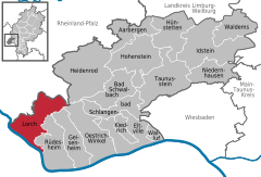
Lorch, Hesse
| Lorch | ||
|---|---|---|
 |
||
|
||
| Coordinates: 50°2′39″N 7°48′12″E / 50.04417°N 7.80333°ECoordinates: 50°2′39″N 7°48′12″E / 50.04417°N 7.80333°E | ||
| Country | Germany | |
| State | Hesse | |
| Admin. region | Darmstadt | |
| District | Rheingau-Taunus-Kreis | |
| Government | ||
| • Mayor | Günter Retzmann | |
| Area | ||
| • Total | 54 km2 (21 sq mi) | |
| Population (2015-12-31) | ||
| • Total | 4,056 | |
| • Density | 75/km2 (190/sq mi) | |
| Time zone | CET/CEST (UTC+1/+2) | |
| Postal codes | 65391 | |
| Dialling codes | 06726 | |
| Vehicle registration | RÜD | |
| Website | www.stadt-lorch-rheingau.de | |
Lorch am Rhein is a small town in the Rheingau-Taunus-Kreis in the Regierungsbezirk of Darmstadt in Hesse, Germany. It belongs to the Rhine Gorge World Heritage Site.
The town is characterized by winegrowing and tourism.
Lorch lies in the southwestern part of the Rheingau-Taunus-Kreis in the foothills of the Rheingaugebirge (range), some 10 km north of the bend in the Rhine near Rüdesheim. The town owes its picturesque setting in the Middle Rhine Valley between Rüdesheim am Rhein and Sankt Goarshausen to its location at the mouth of the Wisper and to its steep vineyards. The town’s municipal area stretches into the richly wooded Wisper valley along Landesstraße (State Road) 3033 between Lorch and the district seat of Bad Schwalbach. The town is a state-recognized recreational resort (Erholungsort). The Rheinsteig, the new hiking trail on the Rhine's right bank leading from Wiesbaden to Bonn, runs on the Rhine heights. In the Rhine near Lorch lies the island and nature conservation area called Lorcher Werth.
Lorch's Stadtteile, besides the main town, also called Lorch, are Lorchhausen, Espenschied, Ransel, Ranselberg, and Wollmerschied.
The area was settled quite early on, first by the Celts, and then, come the Christian Era, by the Ubii and later the Mattiaci. In the first century, the Romans thrust forth to the Taunus. The Romans were followed by the Alamanni and with the onset of the Migration Period, the Franks.
...
Wikipedia


