Odanah
| Odanah, Wisconsin | |
|---|---|
| Census-designated place | |

Odanah on U.S. Route 2
|
|
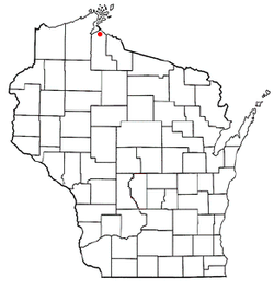
 Location of Odanah, Wisconsin |
|
| Coordinates: 46°36′9″N 90°40′57″W / 46.60250°N 90.68250°WCoordinates: 46°36′9″N 90°40′57″W / 46.60250°N 90.68250°W | |
| Country | United States |
| State | Wisconsin |
| County | Ashland |
| Town | Sanborn |
| Area | |
| • Total | 0.520 sq mi (1.35 km2) |
| • Land | 0.500 sq mi (1.29 km2) |
| • Water | 0.020 sq mi (0.05 km2) |
| Elevation | 610 ft (186 m) |
| Population (2010) | |
| • Total | 13 |
| • Density | 25/sq mi (9.7/km2) |
| Time zone | Central (CST) (UTC-6) |
| • Summer (DST) | CDT (UTC-5) |
| Area code(s) | 715 & 534 |
| FIPS code | 55-59450 |
| GNIS feature ID | 1570746 |
Odanah is a census-designated place (CDP) in Ashland County, Wisconsin, in the town of Sanborn, United States. The population was 13 at the 2010 census.
Odanah is the cultural and administrative center of the Bad River Chippewa Band of the Chippewa.
A post office called Odanah has been in operation since 1855. Odanah is a name derived from the Chippewa language meaning "village".
Odanah is located at 46°36′9″N 90°40′57″W / 46.60250°N 90.68250°W (46.602594, -90.682582), along the Bad River.
According to the United States Census Bureau, the CDP has a total area of .52 square miles (1.3 km²), of which, .5 square miles (1.3 km²) of it is land and 0.02 square miles (0.1 km²) of it (3.85%) is water.
As of the census of 2000, there were 254 people, 94 households, and 64 families residing in the CDP. The population density was 165.2 people per square mile (63.7/km²). There were 104 housing units at an average density of 67.6/sq mi (26.1/km²). The racial makeup of the CDP was 4.72% White, 92.52% Native American, and 2.76% from two or more races. Hispanic or Latino of any race were 2.36% of the population.
...
Wikipedia
