Octodurus
| Martigny | ||
|---|---|---|
 |
||
|
||
| Coordinates: 46°6′N 7°4′E / 46.100°N 7.067°ECoordinates: 46°6′N 7°4′E / 46.100°N 7.067°E | ||
| Country | Switzerland | |
| Canton | Valais | |
| District | Martigny | |
| Government | ||
| • Executive |
Conseil municipal with 9 members |
|
| • Mayor |
Président du conseil municipal (list) Marc-Henri Favre (as of February 2014) |
|
| • Parliament | Conseil communal | |
| Area | ||
| • Total | 25 km2 (10 sq mi) | |
| Elevation | 471 m (1,545 ft) | |
| Population (Dec 2016) | ||
| • Total | 17,998 | |
| • Density | 720/km2 (1,900/sq mi) | |
| Demonym(s) | Les Martignerains | |
| Postal code | 1920 | |
| SFOS number | 6136 | |
| Localities | Chemin-Dessous, La Bâtiaz, La Verrerie, Le Guercet, Martigny-Bourg, Martigny-Ville | |
| Surrounded by | Bovernier, Charrat, Dorénaz, Fully, Martigny-Combe, Salvan, Vernayaz, Vollèges | |
| Twin towns | Vaison-la-Romaine (France), Sursee (Switzerland) | |
| Website |
www SFSO statistics |
|
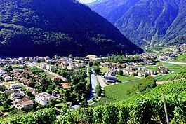
Martigny (French: [maʁtiɲi]; German: Martinach; Latin: Octodurum) is the capital of the district of Martigny in the canton of Valais in Switzerland. It lies at an elevation of 471 meters (1,545 ft), and its population is approximately 15000 inhabitants (Martignerains or "Octoduriens"). It is a junction of roads joining Italy, France and Switzerland. One road links it over the Great St. Bernard Pass to Aosta (Italy), and the other over the col de la Forclaz to Chamonix (France). In winter, Martigny is known for its numerous nearby Alp ski resorts such as Verbier.
Martigny lies at an elevation of 471 meters (1,545 ft), about 33 kilometers (21 mi) south-southeast of Montreux. It is on the left foothills of the steep hillsdies of the Rhone Valley, at the foot of the Swiss Alps, and is located at the point where the southwestern-flowing Rhone turns ninety degrees northward and heads toward (Lake Geneva). The river La Drance flows from the southern Valais Alps (Wallis) through Martigny and joins the Rhone from the left just after Rhone's distinctive, almost rectangular change in direction.
Martigny has an area, as of 2013[update], of 24.97 square kilometers (9.64 sq mi). Of this area, 31.5% is used for agricultural purposes, while 39.8% is forested. Of the rest of the land, 23.3% is settled (buildings or roads) and 5.3% is unproductive land.
...
Wikipedia


