Oakleigh, Victoria
|
Oakleigh Melbourne, Victoria |
|||||||||||||
|---|---|---|---|---|---|---|---|---|---|---|---|---|---|

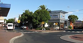
Looking toward Centro Oakleigh Shopping Centre and Railway Station
|
|||||||||||||
| Coordinates | 37°54′47″S 145°06′07″E / 37.913°S 145.102°ECoordinates: 37°54′47″S 145°06′07″E / 37.913°S 145.102°E | ||||||||||||
| Population | 7,535 (2011 census) | ||||||||||||
| • Density | 2,153/km2 (5,580/sq mi) | ||||||||||||
| Postcode(s) | 3166 | ||||||||||||
| Area | 3.5 km2 (1.4 sq mi) | ||||||||||||
| Location | 15 km (9 mi) from Melbourne | ||||||||||||
| LGA(s) | City of Monash | ||||||||||||
| State electorate(s) | Oakleigh | ||||||||||||
| Federal Division(s) | |||||||||||||
|
|||||||||||||
Oakleigh is a suburb of Melbourne, Victoria, Australia 15 km south-east of Melbourne's central business district. Its local government area is the City of Monash. At the 2011 Census, Oakleigh had a population of 7,535.
Once a large independent city, Oakleigh was absorbed into Melbourne as part of the eastward expansion of the metropolis in the 1950s. As a result, it once had its own large historic Central Business District, its own municipality in the former City of Oakleigh and its own suburbs.
The area is traditionally known to have a strong Greek cultural influence, largely due to the influx of said immigrants to Australia in the mid-20th century. Fourteen per cent of those living in the suburb speak only Greek at home.
Although the origin of the name of the suburb, "Oakleigh," is unclear, local historians have three main theories – that it was derived from she-oaks that grew near Scotchmans Creek; from "Oakleigh Park" an estate near Malvern Hills in England; or from Mrs. Oakley an early settler.
Originally inhabited by the Kulin people, a grazing run was established in the settled district east of Melbourne in the early 1840s, for which the lease was taken up by farmers John and Archibald McMillan. Scotchman's Creek Run, as it became known, was named after the Scottish settlers in the area in and near the run (including the McMillan, Campbell, and McPherson families). By 1853, Scotchman's Creek was known as South Yarra Creek, due to the well known South Yarra Pound (built in the area in the early 1840s on behalf of the government to collect stray livestock) and the associated South Yarra Inn. Part of the Parish of Mulgrave, County of Bourke, Oakleigh was first surveyed in 1853, and the first blocks of land were sold soon after. Oakleigh Post Office opened on 1 August 1854.
...
Wikipedia

