Oakes, North Dakota
| Oakes, North Dakota | |
|---|---|
| City | |

The Klein and Sutmar Block on Main Avenue in Oakes
|
|
| Nickname(s): O-Town | |
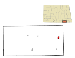
 Location of Oakes, North Dakota |
|
| Coordinates: 46°8′14″N 98°5′23″W / 46.13722°N 98.08972°W | |
| Country | United States |
| State | North Dakota |
| County | Dickey |
| Area | |
| • Total | 1.64 sq mi (4.25 km2) |
| • Land | 1.64 sq mi (4.25 km2) |
| • Water | 0 sq mi (0 km2) |
| Elevation | 1,312 ft (400 m) |
| Population (2010) | |
| • Total | 1,856 |
| • Estimate (2015) | 1,797 |
| • Density | 1,131.7/sq mi (437.0/km2) |
| Time zone | Central (CST) (UTC-6) |
| • Summer (DST) | CDT (UTC-5) |
| ZIP code | 58474 |
| Area code(s) | 701 |
| FIPS code | 38-58740 |
| GNIS feature ID | 1030535 |
| Highways | ND 1 |
| Website | http://www.oakesnd.com |
Oakes is a city in Dickey County, North Dakota, United States. The population was 1,856 at the 2010 census. Oakes was founded in 1886.
Oakes was laid out in 1886. It was named for Thomas F. Oakes, a railroad official. A post office has been in operation in Oakes since 1886. The city was incorporated in 1888.
Oakes is located in southeastern North Dakota at 46°8′14″N 98°5′23″W / 46.13722°N 98.08972°W (46.137249, -98.089686). It sits about one mile east of the James river and is the meeting place of several rail lines. Because of its rail access, Oakes is home to several major grain elevators that handle large volumes of grain, primarily corn.
According to the United States Census Bureau, the city has a total area of 1.64 square miles (4.25 km2), all of it land.
As of the census of 2010, there were 1,856 people, 807 households, and 476 families residing in the city. The population density was 1,131.7 inhabitants per square mile (437.0/km2). There were 912 housing units at an average density of 556.1 per square mile (214.7/km2). The racial makeup of the city was 96.1% White, 0.5% African American, 0.3% Native American, 0.8% Asian, 1.1% from other races, and 1.3% from two or more races. Hispanic or Latino of any race were 3.8% of the population.
...
Wikipedia
