Ołpiny
| Ołpiny | |
|---|---|

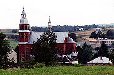
Church in Ołpiny
|
|
| Coordinates: 49°49′N 21°12′E / 49.817°N 21.200°ECoordinates: 49°49′N 21°12′E / 49.817°N 21.200°E | |
| Country |
|
| Voivodeship | Lesser Poland |
| County | Tarnów County |
| Gmina | Gmina Szerzyny |
| Foundation | 1349 |
| Time zone | CET (UTC+1) |
| • Summer (DST) | CEST (UTC+2) |
| Postal code | 32-247 |
| Area code(s) | +48 14 |
| Car plates | KTA |
Ołpiny ([ɔu̯ˈpinɨ]; Yiddish: אלפין Olpin) is a village in the Lesser Poland Voivodeship (province), district of Tarnów, gmina (commune) of Szerzyny, in southeastern Poland.
The village lies in the sub-Carpathian region known as Pogórze Ciężkowickie where the average elevations reach 350 to 420 meters with the highest Gilowa Góra in the village of Swoszowa, 508 meters, Brzanka in Jodłówka Tuchowska, 538 meters, and Dobrocin in Żurowa.
The valley, part of which Ołpiny occupies, runs northwest to southeast. A small river Olszynka flows at the bottom of the valley separating it into two parts in the course of its 24 kilometers. Olszynka has its source on the slopes of Brzanka which is completely covered with forest. The river empties into the Ropa River in Siepietnica.
There is evidence of settlement in the Neolithic (New Stone Age) in stone axes found and displayed at the regional museum in nearby Biecz. These date to 4500-1700 BC. An extensive group of Slavic people who are thought to have migrated from Asia in the 2nd and 3rd millennium BC inhabited an area greater than present Poland. Roman and Byzantine coins found in Biecz indicate an east-west and north-south trade route. In the 880s AD the Kingdom of Moravia extended its influence over this area though much is uncertain except that the people converted to Christianity during this period. The historical period begins in 12th or 13th century.
...
Wikipedia

