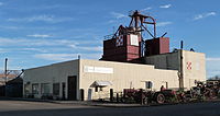
Nyssa, Oregon
| Nyssa, Oregon | |
|---|---|
| City | |

Oregon Trail Agriculture Museum in Nyssa
|
|
| Nickname(s): Thunderegg Capital of the World | |
| Motto: Gateway to the Oregon Trail | |
 Location in Oregon |
|
| Coordinates: 43°52′45″N 116°59′49″W / 43.87917°N 116.99694°WCoordinates: 43°52′45″N 116°59′49″W / 43.87917°N 116.99694°W | |
| Country | United States |
| State | Oregon |
| County | Malheur |
| Incorporated | 1903 |
| Government | |
| • Mayor | Ross Ballard |
| Area | |
| • Total | 1.55 sq mi (4.01 km2) |
| • Land | 1.55 sq mi (4.01 km2) |
| • Water | 0 sq mi (0 km2) |
| Elevation | 2,192 ft (668 m) |
| Population (2010) | |
| • Total | 3,267 |
| • Estimate (2012) | 3,211 |
| • Density | 2,107.7/sq mi (813.8/km2) |
| Time zone | Mountain (UTC-7) |
| • Summer (DST) | Mountain (UTC-6) |
| ZIP code | 97913 |
| Area code(s) | 541 |
| FIPS code | 41-53750 |
| GNIS feature ID | 1124870 |
| Website | www.nyssacity.org |
Nyssa (/ˈnɪsə/) is a city in Malheur County, Oregon, United States. The population was 3,267 at the 2010 census. The city is located along the Snake River on the Idaho border, in the region of far eastern Oregon known as the "Treasure Valley". It is part of the Ontario, OR–ID Micropolitan Statistical Area.
The primary industry in the region is agriculture, including the cultivation of Russet potatoes, sugar beets, onions, corn, flower seed, mint, and wheat. The city's economy relies on the surrounding agricultural area with its several large onion and potato packaging plants.
The area surrounding the city was originally inhabited by Native Americans. Northern Paiute and Cayuse frequented the area but had difficulty living in the relatively harsh climate. The original Fort Boise, established in the 1830s, is nearby to the southeast. The city was originally a shipping center for sheep and stock on the Union Pacific's main trunk line.
Experiments with growing sugar beets were begun in 1935 by R. H. Tallman, the Idaho district manager of the Amalgamated Sugar Company. Successful yields led to the first Amalgamated-designed and built factory, which began operation on October 9, 1938. The factory was located at 43°52′31″N 116°59′26″W / 43.875298°N 116.990629°W, on both the Union Pacific Railroad lines and along U.S. Route 20.
...
Wikipedia
