Nuckolls County, Nebraska
| Nuckolls County, Nebraska | |
|---|---|

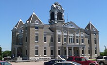
Nuckolls County Courthouse in Nelson
|
|
 Location in the U.S. state of Nebraska |
|
 Nebraska's location in the U.S. |
|
| Founded | 1871 |
| Named for | Stephen Friel Nuckolls |
| Seat | Nelson |
| Largest city | Superior |
| Area | |
| • Total | 576 sq mi (1,492 km2) |
| • Land | 575 sq mi (1,489 km2) |
| • Water | 0.7 sq mi (2 km2), 0.1% |
| Population | |
| • (2010) | 4,500 |
| • Density | 7.8/sq mi (3/km²) |
| Congressional district | 3rd |
| Time zone | Central: UTC-6/-5 |
| Website | www |
Nuckolls County is a county located in the U.S. state of Nebraska. As of the 2010 census, the population was 4,500. Its county seat is Nelson.
In the Nebraska license plate system, Nuckolls County is represented by the prefix 42 (it had the forty-second-largest number of vehicles registered in the county when the license plate system was established in 1922).
Nuckolls County was formed in 1860 and later organized in 1871. It was named after Stephen F. Nuckolls, an early pioneer in this area.
In 1887, Atchison, Topeka and Santa Fe Railway built a branch line from Neva (3 miles west of Strong City) to Superior, Nebraska. This branch line connected Strong City, Neva, Rockland, Diamond Springs, Burdick, Lost Springs, Jacobs, Hope, Navarre, Enterprise, Abilene, Talmage, Manchester, Longford, Oak Hill, Miltonvale, Aurora, Huscher, Concordia, Kackley, Courtland, Webber, Superior. At some point, the line from Neva to Lost Springs was pulled but the right of way has not been abandoned. This branch line was originally called "Strong City and Superior line" but later the name was shortened to the "Strong City line". In 1996, the Atchison, Topeka and Santa Fe Railway merged with Burlington Northern Railroad and renamed to the current BNSF Railway. Most locals still refer to this railroad as the "Santa Fe".
...
Wikipedia
