Nowy Staw
| Nowy Staw | ||
|---|---|---|

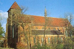
Saint Mathias Church
|
||
|
||
| Coordinates: 54°8′8″N 19°0′48″E / 54.13556°N 19.01333°E | ||
| Country |
|
|
| Voivodeship | Pomeranian | |
| County | Malbork | |
| Gmina | Nowy Staw | |
| Established | 14th century | |
| Town rights | 1343 | |
| Government | ||
| • Mayor | Jerzy Szałach | |
| Area | ||
| • Total | 4.65 km2 (1.80 sq mi) | |
| Population (2006) | ||
| • Total | 4,447 | |
| • Density | 960/km2 (2,500/sq mi) | |
| Time zone | CET (UTC+1) | |
| • Summer (DST) | CEST (UTC+2) | |
| Postal code | 82-230 | |
| Area code(s) | +48 55 | |
| Car plates | GMB | |
| Website | http://um.nowystaw.webpark.pl/ | |
Nowy Staw [ˈnɔvɨ ˈstaf] (German: Neuteich; Kashubian: Nytëch) is a small town in northern Poland on the Święta river in the Żuławy region, with 3 896 inhabitants (2004). Situated in Malbork County in the Pomeranian Voivodeship since 1999, it was previously assigned to Elbląg Voivodeship (1975–1998). City rights were applied in 1345. The name of the town means New Pond. For the history of the region, see Polish Royal Prussia.
Main town buildings:
In 1409 the Teutonic knights started producing in the town, and a few decades later in the middle part of the fifteenth century merchants from nearby Gdańsk erected an Oil mill there.
During the various Swedish Wars Neuteich (as it was known in German-language sources of the time) was on several occasions occupied by Swedish forces and plundered. During the eighteenth century a new district, the "New town" grew up between the existing settlement and the Tuja river. Since that time urban development has taken place in a southerly direction along the right bank of the river.
Coordinates: 54°08′N 19°00′E / 54.133°N 19.000°E
...
Wikipedia


