Novaja Zemlja
| Russian: Но́вая Земля́ | |
|---|---|

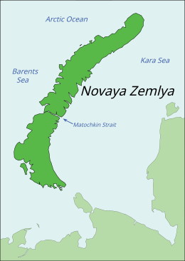
Map of Novaya Zemlya
|
|

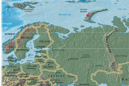
Location of Novaya Zemlya, including the site of the Tsar Bomba detonation
|
|
| Geography | |
| Location | Arctic Ocean |
| Coordinates | 74°N 56°E / 74°N 56°ECoordinates: 74°N 56°E / 74°N 56°E |
| Major islands | 2 |
| Area | 90,650 km2 (35,000 sq mi) |
| Highest elevation | 1,547 m (5,075 ft) |
| Administration | |
| Federal subject | Arkhangelsk Oblast |
| Largest settlement | Belushya Guba (pop. 1,972) |
| Demographics | |
| Population | 2,429 (2010) |
| Novaya Zemlya Test Site | |
|---|---|
 |
|
| Type | Nuclear test site |
| Area | land: 55,200 km2 (21,300 sq mi) water: 36,000 km2 (14,000 sq mi) |
| Site information | |
| Operator | Russian Federation (formerly Soviet Union) |
| Status | Active |
| Site history | |
| In use | 1955 – present |
| Test information | |
| Subcritical tests | not known |
| Nuclear tests | 224 |
Novaya Zemlya (Russian: Но́вая Земля́; IPA: [ˈnovəjə zʲɪmˈlʲa], lit. new land), also known, especially in Dutch, as Nova Zembla, is an archipelago in the Arctic Ocean in northern Russia and the extreme northeast of Europe, the easternmost point of Europe lying at Cape Flissingsky on the Northern island. Administratively, it is incorporated as Novaya Zemlya District, one of the twenty-one in Arkhangelsk Oblast, Russia.Municipally, it is incorporated as Novaya Zemlya Urban Okrug.
Its population as of the 2010 Census was 2,429, of which 1,972 resided in Belushya Guba, an urban-type settlement that is the administrative center of Novaya Zemlya District. The population in 2002 was 2,716 (2002 Census). The indigenous population (from 1872 to the 1950s when it was resettled to the mainland) consisted of about 50–300 Nenetses who subsisted mainly on fishing, trapping, reindeer herding, polar bear hunting and seal hunting. Natural resources include copper, lead, and zinc.
...
Wikipedia
