Norwood, Pennsylvania
| Norwood, Pennsylvania | |
| Borough | |
|
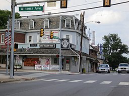
Corner of Winona and Chester
|
|
| Country | United States |
|---|---|
| State | Pennsylvania |
| County | Delaware |
| Elevation | 82 ft (25.0 m) |
| Coordinates | 39°53′18″N 75°17′50″W / 39.88833°N 75.29722°WCoordinates: 39°53′18″N 75°17′50″W / 39.88833°N 75.29722°W |
| Area | 0.8 sq mi (2.1 km2) |
| - land | 0.8 sq mi (2 km2) |
| - water | 0.04 sq mi (0 km2), 5% |
| Population | 5,890 (2010) |
| Density | 7,579.0/sq mi (2,926.3/km2) |
| Timezone | EST (UTC-5) |
| - summer (DST) | EDT (UTC-4) |
| ZIP code | 19074 |
| Area code | 610 and 484 |
| FIPS code | 42-55664 |
| GNIS feature ID | 1182691 |
|
Location in Delaware County and the state of Pennsylvania.
|
|
|
Location of Pennsylvania in the United States
|
|
|
Website: www |
|
Norwood is a borough in Delaware County, Pennsylvania, United States. The population was 5,890 at the 2010 census.
The Morton Morton House was listed on the National Register of Historic Places in 2000.
Morton Morton House
Norwood is located in southeastern Delaware County at 39°53′18″N 75°17′50″W / 39.88833°N 75.29722°W (39.888312, -75.297178). It is bordered to the northeast by Glenolden, to the east by Folcroft, to the south by Tinicum Township, to the west by Prospect Park, and to the west and north by Ridley Township. U.S. Route 13 (Chester Pike) is the main road through the borough, leading northeast 10 miles (16 km) to Center City Philadelphia and southwest 4.5 miles (7.2 km) to Chester.
According to the United States Census Bureau, Norwood has a total area of 0.81 square miles (2.1 km2), of which 0.77 square miles (2.0 km2) is land and 0.04 square miles (0.1 km2), or 4.54%, is water.
...
Wikipedia


