U.S. Route 13
| U.S. Route 13 | |
|---|---|
 |
|
| Route information | |
| Length: | 517.81 mi (833.33 km) |
| Existed: | 1926 – present |
| Major junctions | |
| South end: |
|
|
|
|
| North end: |
|
| Location | |
| States: | North Carolina, Virginia, Maryland, Delaware, Pennsylvania |
| Highway system | |
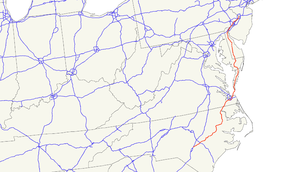
U.S. Route 13 (US 13) is a north–south U.S. highway established in 1926 that runs for 517 miles (832 km) from Interstate 95 just north of Fayetteville, North Carolina to the northeastern suburbs of Philadelphia, Pennsylvania, in Morrisville. In all, it traverses five states in the Atlantic coastal plain region, following the Atlantic coast more closely than does the main north–south U.S. highway of the region, U.S. Route 1. Its routing is largely rural, the notable exceptions being the Hampton Roads area and the northern end of the highway in Delaware and Pennsylvania. It is also notable for being the main thoroughfare for the Delmarva Peninsula and carrying the Chesapeake Bay Bridge–Tunnel to it in Virginia.
US 13's original plan in 1926 had the route serve no further south than the Delmarva Peninsula. However, it has been extended many times, connecting to the mainland via ferry service and eventually reaching North Carolina. This link across the mouth of the Chesapeake Bay became fixed in 1964 with a bridge-tunnel. The entire route on the Delmarva Peninsula save a few sections in Accomack County, Virginia have been dualized fully with four lanes, and further upgrades continue, such as a freeway section around the east side of Salisbury, Maryland.
...
Wikipedia

