Norwood, Bronx
| Norwood | |
|---|---|
| Neighborhood of The Bronx | |

|
|
| Location in New York City | |
| Coordinates: 40°52′46″N 73°52′47″W / 40.87953°N 73.87959°WCoordinates: 40°52′46″N 73°52′47″W / 40.87953°N 73.87959°W | |
| Country |
|
| State |
|
| City |
|
| Borough |
|
| Area | |
| • Total | 1.36 km2 (0.525 sq mi) |
| Population (2010) | |
| • Total | 40,494 |
| • Density | 30,000/km2 (77,000/sq mi) |
| Economics | |
| • Median income | $37,465 |
| ZIP codes | 10467 |
| Area code | 718, 347, 646 |
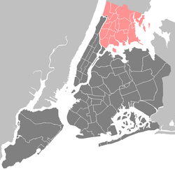
Norwood, also known as Bainbridge, is a working-class residential neighborhood in the northwest Bronx, New York City. As of the census of 2000, the seven census tracts that make up the neighborhood have a population of 40,748. The area is dominated topographically by what was once known as Valentine's Hill, the highest point being near the intersection of 210th Street and Bainbridge Avenue, where Gun Hill Road intersects, and around the Montefiore Medical Center, the largest landowner and employer of the neighborhood. It borders Van Cortlandt Park and Woodlawn Cemetery to the north, the Bronx River to the east, and Mosholu Parkway to the south and west. Norwood's main commercial arteries are Gun Hill Road, Jerome Avenue, Webster Avenue, and Bainbridge Avenue.
Due to its use in city publications, subway maps, and local media, "Norwood" is the neighborhood's more common name, but the area is also known as "Bainbridge," most consistently within the neighborhood's Irish American community that is centered on the commercial zone of Bainbridge Avenue and East 204th Street. However, as this Irish community largely left the country during the 1990s, the name "Bainbridge" has accordingly lost a great deal of currency. Even the name "Norwood" does not carry a great deal of currency as do nearby neighborhoods such as Riverdale and Woodlawn.
It is part of Bronx Community Board 7 and is patrolled by the NYPD's 52nd Precinct, located at 3016 Webster Avenue.
At the time of the Civil War, the area was Westchester County farmland on the border of West Farms and Yonkers. Chief property owners included the Valentine, Varian, and Bussing families. Woodlawn Cemetery was founded in 1863 to the north. Annexed to New York City in 1873 along with the rest of the West Bronx, the area's character shifted from rural to suburban by the turn of the 20th century. The neighborhood's streets in their present form were laid out in 1889 by Josiah Briggs between Middlebrook Parkway (renamed Mosholu Parkway) and Woodlawn Cemetery. Contemporary maps show that it was then considered part of Williamsbridge, with which it continues to share a post office. Williamsbridge Reservoir was opened in 1890, transforming the natural lake into an artery that served the New York City water supply system until no longer needed in 1934.
...
Wikipedia


