Northern Croatian Littoral
|
Croatian Littoral Hrvatsko primorje |
|
|---|---|
| Geographic region of Croatiaa | |
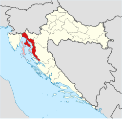
 Croatian Littoral on a map of Croatia Croatian Littoral Sometimes considered part of the Croatian Littoral |
|
| Country |
|
| Largest city | Rijeka |
| Areab | |
| • Total | 2,830 km2 (1,090 sq mi) |
| Population (2011)b | |
| • Total | 228,725 |
| • Density | 81/km2 (210/sq mi) |
|
a Croatian Littoral is not designated as an official region; it is a geographic region only. b The figure is an approximation based on the territorial span and population of the municipalities bounded by geographic regions of Istria, Mountainous Croatia, and Dalmatia, including the Kvarner Gulf islands. |
|
| The most populous urban areas in Croatian Littoral | ||||||||||
|---|---|---|---|---|---|---|---|---|---|---|
| Rank | City | County | Urban population | Municipal population | ||||||
| 1 | Rijeka | Primorje-Gorski Kotar | 127,498 | 128,735 | ||||||
| 2 | Crikvenica | Primorje-Gorski Kotar | 6,880 | 11,193 | ||||||
| 3 | Mali Lošinj | Primorje-Gorski Kotar | 5,990 | 8,070 | ||||||
| 4 | Senj | Lika-Senj | 4,822 | 7,165 | ||||||
| 5 | Kostrena | Primorje-Gorski Kotar | 4,158 | 4,179 | ||||||
| Sources: Croatian Bureau of Statistics, 2011 Census | ||||||||||
a Croatian Littoral is not designated as an official region; it is a geographic region only.
Croatian Littoral (Croatian: Hrvatsko primorje) is a region of Croatia comprising the area between Dalmatia to the south, Mountainous Croatia to the north and east, and Istria and the Kvarner Gulf of the Adriatic Sea to the west. The term "Croatian Littoral" developed relatively recently, since the 18th and 19th centuries, reflecting the complex development of Croatia in historical and geographical terms. The term Croatian Littoral is also applied to entire Adriatic coast of modern Croatia in general terms, which is then divided into the Southern Croatian Littoral comprising Dalmatia, and the Northern Croatian Littoral comprising Istria and Croatian Littoral in the strict meaning of the term. Croatian Littoral covers 2,830 square kilometres (1,090 square miles) and has a population of 228,725. More than half the region's population lives in the city of Rijeka—by far the largest urban centre in the area.
The foothills of mountains that form the northeast boundary of the region, as well as islands in the Kvarner Gulf, are a part of the Dinaric Alps, making karst topography especially prominent in the Croatian Littoral. The Cres – Lošinj and Krk – Rab island chains divide the Kvarner Gulf into four distinct areas—Rijeka Bay, Kvarner (sensu stricto), Kvarnerić, and Vinodol Channel. The Cres – Lošinj group also includes the inhabited islands of Ilovik, Susak, Unije, Vele Srakane, and Male Srakane, as well as a larger number of small uninhabited islands. Zadar Archipelago extends to the southeast of the island group. Water significantly contributed to the geomorphology of the area, especially in the Bay of Bakar, a ria located between Rijeka and Kraljevica. The most significant inland bodies of water in the region are the 17.5-kilometre (10.9-mile) long Rječina River and Lake Vrana on the island of Cres.
...
Wikipedia


