Ilovik
|
Native name: Ilovik, Sveti Petar Nickname: San Piero, Šan Pjero |
|
|---|---|

Port of Ilovik
|
|
 |
|
| Geography | |
| Location | Adriatic Sea, Kvarner Bay |
| Coordinates | 44°28′N 14°33′E / 44.467°N 14.550°ECoordinates: 44°28′N 14°33′E / 44.467°N 14.550°E |
| Archipelago | Cres-Lošinj archipelago |
| Area | 5.8 km2 (2.2 sq mi) |
| Coastline | 15.4 km (9.57 mi) |
| Highest point | Dida- 95 m |
| Administration | |
|
Croatia
|
|
| County | Primorje-Gorski Kotar |
| Largest settlement | Ilovik (pop. 85) |
| Mayor | Jadranka Matas |
| Demographics | |
| Population | 85 (2011) |
| Pop. density | 14.7 /km2 (38.1 /sq mi) |
| Ethnic groups | Croats 99.9% Other 1% |
| Additional information | |
|
license plate registration = RI (Rijeka) (no cars) |
|
license plate registration = RI (Rijeka) (no cars)
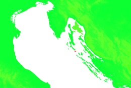
The islands of Ilovik (Italian: Asinello) and Sveti Petar (Italian: San Pietro) are located in Croatia south of the island Lošinj (Lussino), separated by the Strait of Ilovik (Croatian: Ilovačka vrata).
The only village located on the island of Ilovik is also called Ilovik. The circumference of the island is 15.4 km (9.6 mi), and it occupies an area of 5.8 km2 (1,400 acres). The coast is accessible from all sides with many secluded bays. The largest bay with a sandy beach is Paržine, located on the south-eastern part of the island. Paržine is connected to the village by a road, as is the beach Parknu, which includes a World War II bunker. Beaches with easier access from the village include Harbac, Šoto Pini and Sidro. Also at Šoto Pini, which means 'under the pines' is a small soccer field where some intense games take place. The island also has a bocce court.
Ilovik and Sveti Petar are separated by an inlet which is 2.5 km (1.6 mi) long and 300 metres (980 feet) wide. The location of the inlet offers a natural barrier from most winds, except partially from the jugo (south wind) and bura. The convenient location of this harbor makes it a favorite rest stop between the northern and southern parts of the Adriatic. In only a few hours, you can reach Istria, Rijeka, Krk, Rab, Pag, Kornati and other mid-Dalmatian destinations.
In the town you will find a well-stocked store, post office, currency exchange office and several restaurants.
The island is covered with Mediterranean vegetation. Throughout the town you will find oleander in various colours, bougainvillea, palm trees, and two century-old eucalyptus trees. It is because of the abundance of flora that this island has been nicknamed "The Island of Flowers". Olive trees and grape vines still populate the island and are cultivated by inhabitants for personal use. Pine trees are found throughout the island, the most impressive of which are found on the north east side.
...
Wikipedia
