Northborough (town), Massachusetts
| Northborough, Massachusetts | ||
|---|---|---|
| Town | ||

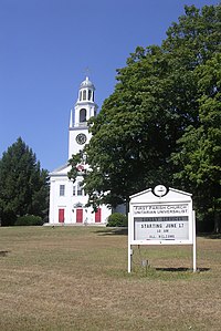
First Parish Church
|
||
|
||
 Location in Worcester County and the state of Massachusetts. |
||
| Coordinates: 42°19′10″N 71°38′30″W / 42.31944°N 71.64167°WCoordinates: 42°19′10″N 71°38′30″W / 42.31944°N 71.64167°W | ||
| Country | United States | |
| State | Massachusetts | |
| County | Worcester | |
| Settled | 1672 | |
| Incorporated | 1766 | |
| Government | ||
| • Type | Open town meeting | |
| • Town Administrator |
John W. Coderre | |
| • Board of Selectmen |
Bill Pantazis Aaron Hutchins Leslie Rutan Jeff Amberson Dawn Rand |
|
| Area | ||
| • Total | 18.8 sq mi (48.6 km2) | |
| • Land | 18.5 sq mi (48.0 km2) | |
| • Water | 0.2 sq mi (0.6 km2) | |
| Elevation | 300 ft (91 m) | |
| Population (2010) | ||
| • Total | 14,155 | |
| • Density | 750/sq mi (290/km2) | |
| Demonym(s) | Northboronian | |
| Time zone | Eastern (UTC-5) | |
| • Summer (DST) | Eastern (UTC-4) | |
| ZIP code | 01532 | |
| Area code(s) | 508 / 774 | |
| FIPS code | 25-46820 | |
| GNIS feature ID | 0618375 | |
| Website | town.northborough.ma.us | |
Northborough is a town in Worcester County, Massachusetts, United States. The official spelling of the town's name is "Northborough", but the alternative spelling "Northboro" is also used. The population was 14,155 at the 2010 census.
The areas surrounding Northborough were first settled by Nipmuc Indians. Europeans set up a plantation on May 14, 1656, following a petition for resettlement from the people of the Sudbury Plantation to the General Court of the Bay Colony. On January 24, 1766, the district of Northborough was established within neighboring Westborough. On August 23, 1775, the district became a town, and on June 20, 1807 part of neighboring Marlborough was annexed to Northborough.
The first meeting house was established in 1746, with the legal governor of the town being called the Town Minister. The first Town Minister was Reverend John Martyn.
In 1775, Northborough split off as the "north borough" of Westborough, much as Westborough split off from Marlborough some 58 years before. However, the two towns shared a meetinghouse for some time more.
According to the United States Census Bureau, the town has a total area of 18.8 square miles (49 km2), of which 18.5 square miles (48 km2) is land and 0.2 square miles (0.52 km2), or 1.17%, is water.
Northborough is located in Central Massachusetts, and shares a border with five towns and one city:
Of the six towns that make up Northborough's borders, and including Northborough as the seventh, Northborough is the fourth largest town by population. Marlborough is the largest while Berlin is the smallest.
By the 2010 census, the population had reached 14155.
As of the census of 2000, there were 14,013 people, 4,906 households, and 3,865 families residing in the town. The population density was 756.1 inhabitants per square mile (291.9/km2). There were 5,002 housing units at an average density of 269.9 per square mile (104.2/km2). The racial makeup of the town was 93.01% White, 0.65% Black or African American, 0.08% Native American, 5.05% Asian, 0.07% Pacific Islander, 0.36% from other races, and 0.78% from two or more races. Hispanic or Latino of any race were 1.28% of the population.
...
Wikipedia

