North Yarmouth, Maine
| North Yarmouth, Maine | |||
|---|---|---|---|
| Town | |||
| Town of North Yarmouth | |||
|
|||
| Motto: "The Town Where Others Began" | |||
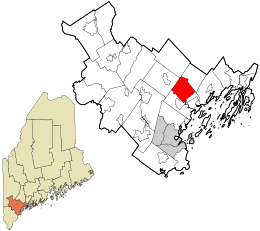
 Location in Cumberland County and the state of Maine. |
|||
| Coordinates: 43°51′28″N 70°14′25″W / 43.85778°N 70.24028°WCoordinates: 43°51′28″N 70°14′25″W / 43.85778°N 70.24028°W | |||
| Country | United States of America | ||
| State | Maine | ||
| County | Cumberland | ||
| Settled | 1636 | ||
| Incorporated | September 22, 1680 | ||
| Area | |||
| • Total | 21.41 sq mi (55.45 km2) | ||
| • Land | 21.22 sq mi (54.96 km2) | ||
| • Water | 0.19 sq mi (0.49 km2) | ||
| Elevation | 226 ft (69 m) | ||
| Population (2010) | |||
| • Total | 3,565 | ||
| • Estimate (2012) | 3,611 | ||
| • Density | 168.0/sq mi (64.9/km2) | ||
| Time zone | Eastern (EST) (UTC-5) | ||
| • Summer (DST) | EDT (UTC-4) | ||
| ZIP code | 04097 | ||
| Area code(s) | 207 | ||
| FIPS code | 23-53860 | ||
| GNIS feature ID | 0582642 | ||
| Website | www |
||
North Yarmouth, officially the Town of North Yarmouth, is a town in Cumberland County, Maine. The population was 3,565 at the 2010 United States Census. It is part of the Portland–South Portland–Biddeford Metropolitan Statistical Area.
According to the United States Census Bureau, the town has a total area of 21.41 square miles (55.45 km2), of which, 21.22 square miles (54.96 km2) of it is land and 0.19 square miles (0.49 km2) is water.
The area embracing North Yarmouth, first settled in 1636, was abandoned twice before successful final settlement in 1713. In 1646, William Royall purchased a farm on the river that, since, has borne his name. John Cousins, a few years previous, occupied a neck of land between branches of a stream and owned an island, both now bearing his name. These settlements were established in the vicinity, called by the Wabanakis, as “Wescustogo”. Yarmouth originally constituted the eastern portion of North Yarmouth; the “North” in the name intended to differentiate it from Yarmouth, Massachusetts, on Cape Cod (Maine was then a part of Massachusetts). North Yarmouth was chartered on September 22, 1680, encompassing the area of the present Town of North Yarmouth and the future towns of Harpswell (until 1750), Freeport (until 1789), Pownal (until 1808, from Freeport), Cumberland (until 1821), and Yarmouth (until 1849).
As of the census of 2010, there were 3,565 people, 1,297 households, and 1,036 families residing in the town. The population density was 168.0 inhabitants per square mile (64.9/km2). There were 1,354 housing units at an average density of 63.8 per square mile (24.6/km2). The racial makeup of the town was 97.4% White, 0.2% African American, 0.1% Native American, 1.0% Asian, 0.3% from other races, and 1.1% from two or more races. Hispanic or Latino of any race were 0.9% of the population.
...
Wikipedia


