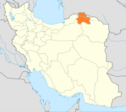
North Khorasan Province
|
North Khorasan Province استان خراسان شمالی |
|
|---|---|
| Province | |
 Location of North Khorasan within Iran |
|
| Coordinates: 37°28′34″N 57°19′54″E / 37.4761°N 57.3317°E | |
| Country |
|
| Region | Region 5 |
| Capital | Bojnord |
| Counties | 7 |
| Area | |
| • Total | 28,434 km2 (10,978 sq mi) |
| Population (2011) | |
| • Total | 867,727 |
| • Density | 31/km2 (79/sq mi) |
| Time zone | IRST (UTC+03:30) |
| • Summer (DST) | IRST (UTC+04:30) |
| Main languages |
Persian Kurdish Turkmen Khorasani Turkic |
North Khorasan Province (Persian: استان خراسان شمالی, Ostān-e Khorāsān-e Shomālī) is a province located in northeastern Iran. Bojnord is the capital of the province. In 2014 it was placed in Region 5.
Other counties are Shirvan, Esfarayen, Maneh and Samalqan, Raz and Jargalan county Jajarm, Faroj and Garmeh.
North Khorasan is one of the three provinces that were created after the division of Khorasan in 2004.
Greater Khorasan has witnessed the rise and fall of many dynasties and governments in its territory throughout history. Various tribes of Persians, Arabs, Turks, Kurds, Mongols, Turkmen, and Afghans have brought change to the region time and time again.
Ancient geographers of Iran divided Iran ("Iran-Shahr") into eight segments of which the most flourishing and largest was the territory of Greater Khorasan. Esfarayen, among other cities of the province, was one of the focal points for settlement by Aryan tribes entering Iran.
The Parthian empire was based near Merv in Khorasan for many years. In Parthian times, Esfarayen was one of the important villages of Nishapur.
During the Sassanid dynasty the province was governed by a Spahbod (Lieutenant General) called "Padgoosban" and four margraves, each commander of one of the four parts of the province.
Khorasan was divided into four parts during the Muslim conquest of Persia, each section being named after the four largest cities, Nishapur, Merv, Herat, and Balkh.
...
Wikipedia
