North Kalimantan
|
North Kalimantan Kalimantan Utara |
||
|---|---|---|
| Province | ||
|
||
| Motto: Benuanta | ||
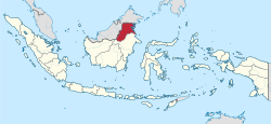
 North Kalimantan in Indonesia |
||
| Country | Indonesia | |
| Capital | Tanjung Selor | |
| Largest city | Tarakan | |
| Government | ||
| • Acting Governor | Irianto Lambrie | |
| Area | ||
| • Total | 72,275.12 km2 (27,905.58 sq mi) | |
| Population (2013) | ||
| • Total | 628,331 | |
| • Density | 8.7/km2 (23/sq mi) | |
| Demographics | ||
| • Ethnic groups | Tidung, Bulungan, Banjar, Dayak, Lun Bawang, Murut, Kenyah, Bugis, Bajau and Tausūg | |
| • Languages | Indonesian (official), Tidung, and Dayak | |
| Time zone | WITA (UTC+8) | |
| Vehicle registration | KU | |
| HDI |
|
|
| HDI rank | 34 (2014) | |
| Website | www.kaltaraprov.go.id | |
North Kalimantan (Indonesian: Kalimantan Utara) is a province of Indonesia. It is located on the Indonesian part of the island of Borneo. The territory now comprising the province had a population of approximately 525,000 according to the 2010 census; the latest official estimate (for December 2013) is 628,331.
North Kalimantan borders the Malaysian states of Sabah to the north and Sarawak to the west, and by the Indonesian province of East Kalimantan to the south.
Formed on 25 October 2012, it is the newest province in Indonesia. It covers 72,275.12 square kilometres. The province's territory had been part of East Kalimantan.
It was the fastest growing province in the nation for 2015 census, edging Papua and Riau which had phenomenal growth the prior 5-year period.
Tarakan Airport on the eponymous island serves the province, as well as an international ferry port with services to Malaysia from Tawau. There are no international land crossings – entrance into the mainland of the province is by ferry from Tarakan or by road from the south. Large stretches of the roads in this province are of unpaved muddy ditches.
North Kalimantan is divided into four regencies (kabupaten) and one city (kota):
Coordinates: 3°24′54″N 116°27′48″E / 3.4151°N 116.4633°E
...
Wikipedia

