North Island of New Zealand

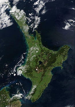
Satellite image of the North Island
|
|
| Geography | |
|---|---|
| Location | Oceania |
| Coordinates | 38°24′S 175°43′E / 38.400°S 175.717°E |
| Archipelago | New Zealand |
| Area | 113,729 km2 (43,911 sq mi) |
| Area rank | 14th |
| Highest elevation | 2,797 m (9,177 ft) |
| Highest point | Mount Ruapehu |
| Administration | |
|
New Zealand
|
|
| ISO 3166-2:NZ | NZ-N |
| Regions | 9 |
| Territorial authorities | 43 |
| Largest settlement | Auckland (pop. 1,495,000) |
| Demographics | |
| Population | 3,596,200 (June 2016) |
| Pop. density | 31.6 /km2 (81.8 /sq mi) |
| Urban areas of the North Island by population | ||||||||||
|---|---|---|---|---|---|---|---|---|---|---|
| Urban area | Region | Population (June 2016) | Urban area | Region | Population (June 2016) | |||||
| 1 | Auckland | Auckland | 1,495,000 | 11 | Wanganui | Manawatu-Wanganui | 39,600 | |||
| 2 | Wellington | Wellington | 405,000 | 13 | Gisborne | Gisborne | 36,100 | |||
| 3 | Hamilton | Waikato | 230,000 | 13 | Pukekohe | Auckland | 29,800 | |||
| 4 | Tauranga | Bay of Plenty | 134,400 | 14 | Taupo | Waikato | 24,100 | |||
| 5 | Napier-Hastings | Hawke's Bay | 131,000 | 15 | Masterton | Wellington | 21,200 | |||
| 6 | Palmerston North | Manawatu-Wanganui | 84,300 | 16 | Levin | Manawatu-Wanganui | 20,600 | |||
| 7 | Rotorua | Bay of Plenty | 57,800 | 17 | Whakatāne | Bay of Plenty | 19,600 | |||
| 8 | New Plymouth | Taranaki | 56,800 | 18 | Feilding | Manawatu-Wanganui | 16,250 | |||
| 9 | Whangarei | Northland | 56,400 | 19 | Tokoroa | Waikato | 13,700 | |||
| 10 | Kapiti | Wellington | 41,800 | 20 | Hawera | Taranaki | 11,800 | |||
The North Island or Te Ika-a-Māui (Māori) is one of the two main islands of New Zealand, separated from the slightly larger but much less populous South Island by Cook Strait. The island's area is 113,729 square kilometres (43,911 sq mi), making it the world's 14th-largest island. It has a population of 3,596,200 (June 2016).
Twelve main urban areas (half of them officially cities) are in the North Island. Listing from north to south, they are Whangarei, Auckland, Hamilton, Tauranga, Rotorua, Gisborne, New Plymouth, Napier, Hastings, Whanganui, Palmerston North, and Wellington, the capital, located at the south-west extremity of the island. About 77% of New Zealand's population lives in the North Island.
Although the island has been known as the North Island for many years, in 2009 the New Zealand Geographic Board found that, along with the South Island, the North Island had no official name. After a public consultation, the board officially named the island North Island or Te Ika-a-Maui in October 2013.
In prose, the two main islands of New Zealand are called the North Island and the South Island, with the definite articles. It is normal to use the preposition in rather than on, for example "Hamilton is in the North Island", "my mother lives in the North Island". Maps, headings, tables and adjectival expressions use North Island without the.
According to Māori mythology, the North and South Islands of New Zealand arose through the actions of the demigod Māui. Māui and his brothers were fishing from their canoe (the South Island) when he caught a great fish and pulled it from the sea. While he was not looking his brothers fought over the fish and chopped it up. This great fish became the North Island and thus a Māori name for the North Island is Te Ika-a-Māui (The Fish of Māui). The mountains and valleys are believed to have been formed as a result of Māui's brothers' hacking at the fish. Until the early 20th Century, an alternative Māori name for the North Island was Aotearoa. In present usage, Aotearoa is a collective name for New Zealand as a whole.
...
Wikipedia

