North East, Pennsylvania
| North East, Pennsylvania | |
|---|---|
| Borough | |

Main Street, looking west toward Lake Street (PA 89)
|
|
| Etymology: North East Township | |
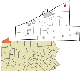
 Location in Erie County and the state of Pennsylvania |
|
| Coordinates: 42°12′48″N 79°50′1″W / 42.21333°N 79.83361°WCoordinates: 42°12′48″N 79°50′1″W / 42.21333°N 79.83361°W | |
| Country | United States |
| State | Pennsylvania |
| County | Erie |
| Settled | 1800 |
| Government | |
| • Mayor | Steve Gregory |
| Area | |
| • Total | 1.3 sq mi (3.4 km2) |
| • Land | 1.3 sq mi (3.4 km2) |
| • Water | 0.0 sq mi (0.0 km2) |
| Elevation | 801 ft (244 m) |
| Population (2010) | |
| • Total | 4,294 |
| • Density | 3,296/sq mi (1,272.5/km2) |
| Time zone | EST (UTC-4) |
| • Summer (DST) | EDT (UTC-5) |
| ZIP code | 16428 |
| Area code(s) | 814 |
| Website | northeastborough |
North East is a borough in Erie County, Pennsylvania, United States, 14 miles (23 km) northeast of Erie in the state's northwestern corner. Fruit growing was an early economic endeavor, and is still to this day, as this is a popular area for especially cherries and grapes. There is an annual Cherry Festival in the summer and an annual Wine Country Harvest Festival in the fall. It contains one college, Mercyhurst North East. The population was 4,294 at the 2010 census, down from 4,601 at the 2000 census. It is part of the Erie Metropolitan Statistical Area. It is the northernmost town in Pennsylvania. The name "North East" seems to be a misnomer since the borough is located in extreme northwestern Pennsylvania, but it is so named for its northeastern-most location within Erie County.
The North East Historic District was added to the National Register of Historic Places in 1990. Short's Hotel was listed in 1983.
North East is located in northeastern Erie County at 42°12′48″N 79°50′1″W / 42.21333°N 79.83361°W (42.213385, -79.833711). It is surrounded by North East Township.
...
Wikipedia
