North Brookfield, Massachusetts
| North Brookfield, Massachusetts | ||
|---|---|---|
| Town | ||

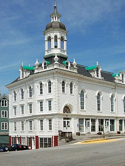
North Brookfield Town Hall
|
||
|
||
 Location in Worcester County and the state of Massachusetts. |
||
| Coordinates: 42°16′00″N 72°05′00″W / 42.26667°N 72.08333°WCoordinates: 42°16′00″N 72°05′00″W / 42.26667°N 72.08333°W | ||
| Country | United States | |
| State | Massachusetts | |
| County | Worcester | |
| Settled | 1664 | |
| Incorporated | 1812 | |
| Government | ||
| • Type | Open town meeting | |
| • Administrative Assistant | Leslie Scott Burton | |
| • Board of Selectmen |
Robert Filipkowski, Jason Petraitis, Mary Walter | |
| Area | ||
| • Total | 21.7 sq mi (56.3 km2) | |
| • Land | 21.1 sq mi (54.5 km2) | |
| • Water | 0.7 sq mi (1.7 km2) | |
| Elevation | 915 ft (279 m) | |
| Population (2010) | ||
| • Total | 4,680 | |
| • Density | 220/sq mi (83/km2) | |
| Time zone | Eastern (UTC-5) | |
| • Summer (DST) | Eastern (UTC-4) | |
| ZIP code | 01535 | |
| Area code(s) | 508 / 774 | |
| FIPS code | 25-47135 | |
| GNIS feature ID | 0618377 | |
| Website | http://www.northbrookfield.net/ | |
North Brookfield is a town in Worcester County, Massachusetts, United States. The population was 4,680 at the 2010 census.
For geographic and demographic information on the census-designated place North Brookfield, please see the article North Brookfield (CDP), Massachusetts.
North Brookfield was first settled in 1664 and was officially incorporated in 1812, splitting from neighboring Brookfield.
The town's lands were formerly a part of the Quaboag Plantation.
According to the United States Census Bureau, the town has a total area of 21.7 square miles (56 km2), of which 21.1 square miles (55 km2) are land and 0.7 square miles (1.8 km2), or 3.04%, is water. North Brookfield is bounded on the east by Spencer, on the south by East Brookfield and Brookfield, on the west by West Brookfield, and on the north by New Braintree. The junction of North Brookfield, Spencer and New Braintree is also shared by the town of Oakham; however, Brooks Pond cuts that point, as well as two others, off from the rest of the town.
As of the census of 2000, there were 4,683 people, 1,811 households, and 1,235 families residing in the town. The population density was 222.3 people per square mile (85.9/km²). There were 1,902 housing units at an average density of 90.3 per square mile (34.9/km²). The racial makeup of the town was 97.65% White, 0.34% Black or African American, 0.26% Native American, 0.21% Asian, 0.36% from other races, and 1.17% from two or more races. Hispanic or Latino of any race were 1.09% of the population.
...
Wikipedia

